Author Topic: Sending a track to Vista HCx  (Read 3035 times)

meddyg

  • 'You'll have had your tea?'
Sending a track to Vista HCx
« on: 09 June, 2010, 09:53:09 pm »
I usually use takitwithme (TakItWithMe - TakItWithMe - GPX Uploader) to upload routes.
However  when I want to upload a track* I can't see the easy way to make it drop into
tracks; even resorting to Trip and Waypoint manager (ugh) it loads my track as a route and sends it to device as as route. What am I doing wrong?

this for Pembrokeshire cylosportive 104 km with 1139 waypoints.
(::Welcome to Tour of Pembrokeshire::)

Thanks in anticipation

Re: Sending a track to Vista HCx
« Reply #1 on: 09 June, 2010, 09:58:09 pm »
What are you using to create the route or track in the first place?

Re: Sending a track to Vista HCx
« Reply #2 on: 09 June, 2010, 10:01:32 pm »
I:ve just downloaded the the gpx file for the short route ToP_short.gpx, unzipped it and opened it in MapSource and it appears as a route not a track. and looking at the xml document in a text editor I see it's a route.

You've done nowt wrong

do you really want a track ?

Wowbagger

  • Stout dipper
    • Stuff mostly about weather
Re: Sending a track to Vista HCx
« Reply #3 on: 09 June, 2010, 10:02:02 pm »
I use Bikehike, which is excellent for route-plotting.

Before downloading, click the "Options" button and set the maximum number of points to 500. If you don't do this any track longer than about 25 miles is likely to be truncated.

Then click the "Download" button, specifying that you want to save it as a .gpx file. I believe that you can save it straight to the GPX but I've never tried this.

I then use LoadMyTracks (I'm using a Mac) to transfer it via the USB cable.
Quote from: Dez
It doesn’t matter where you start. Just start.

Re: Sending a track to Vista HCx
« Reply #4 on: 09 June, 2010, 10:03:44 pm »
It seems to me, and hence my post above, is that you have created a route, by whichever means, rather than the track that you want in this instance. Try GPSBabel, to convert those routes to tracks.

meddyg

  • 'You'll have had your tea?'
Re: Sending a track to Vista HCx
« Reply #5 on: 10 June, 2010, 07:20:06 pm »
Well perhaps the organisers just want us to follow the cardboard signs in the lanes!
Because their route has >1100 waypoints, it get truncated to 250 points and loads to Garmin
as a route which then issues a warning ''only fifty points can be used for follow road navigation."

I've been here before ! http://yacf.co.uk/forum/index.php?topic=18870.0

On a more general (newbie) point though all the trips I load(created in 'Marengo' or Google maps end up as routes & Garmin haven't really made it intuitive and their manual doesn't help much
 -which is why I'm here!!

frankly frankie

  • I kid you not
    • Fuchsiaphile
Re: Sending a track to Vista HCx
« Reply #6 on: 10 June, 2010, 07:52:41 pm »
Well i have to say that none of your compaints are Garmin's problem (except perhaps the inadequate manual).

An Organiser's supplied route and two items of 3rd-party software.
And the 50 points message is down to the way your GPS is set up, with suitable menu settings you'd never see it.
when you're dead you're done, so let the good times roll

Re: Sending a track to Vista HCx
« Reply #7 on: 10 June, 2010, 08:26:22 pm »

And the 50 points message is down to the way your GPS is set up, with suitable menu settings you'd never see it.
Come on then Frankie, help us out. What do we change to remove these limitations ?

Manotea

  • Where there is doubt...
Re: Sending a track to Vista HCx
« Reply #8 on: 10 June, 2010, 08:32:53 pm »
Don't think you can. What I would do would be to use WINGDB3 to convert the route into a track, make a copy and filter it down to 500 track points, make another copy and filter it down to 50 track points, convert the 50 point into a route and copy the 500 pt track and 50 track route into a GDB for uploading to give a static track and dynamic route for use in follow road mode.

Frankie would probably just advise to convert the route to a track and rename it ACTIVE LOG so you can upload without hitting the max trackpooint limit. Or something like that.

Re: Sending a track to Vista HCx
« Reply #9 on: 11 June, 2010, 10:59:02 am »
Ok, I've tried this now. I downloaded and installed WinGDB3 vers. 3.55 Beta. I created a 100km Route in Garmin MapSource and saved it as a .gdb file. I then used WinGDB3 Option 11 "Convert Routes to Tracks with all route points" using the "Split and filter to max 500 points" option and saved the output as a separate .gdb file. This showed three Tracks of 386 points each, following the path of the original Route. So far, so good.

Using MapSource, I amalgamated the Route and Tracks into one .gdb file and downloaded this amalgamated file into my GPSMap60CSx unit. Took the Map60 outside and fired it up; I can see the Route - set this to "Navigate" (coloured magenta - I don't think I have the option to recolour or render this transparent - ?). In Tracks menu however I have only ONE Track, the third and final one of the three contained in my original .gdb file. This I can display coloured cyan and it shows through the magenta route path very nicely.

But what's happened to my other two Tracks? It appeared that WinGDB3 worked fine. I have tried reloading the three Tracks from the .dgb file after separating them into a new file of their own, but with the same result.

Any suggestions? Am I doing something wrong with WinGDB3?

Re: Sending a track to Vista HCx
« Reply #10 on: 11 June, 2010, 11:02:04 am »
do all three tracks have the same name ? Not file name, trackname. I suggest that the GPS has over written the first two.

Euan Uzami

Re: Sending a track to Vista HCx
« Reply #11 on: 11 June, 2010, 11:06:59 am »
as a route which then issues a warning ''only fifty points can be used for follow road navigation."


IMHO you really don't want to use follow road mode with a pre-planned route, it'll usually give you several wrong turnings. This is more prevalent the more dense the points are.
Follow road mode is only good for getting to a particular point, using whatever route the garmin decides (i.e. a route that you don't know.)
The whys and wherefores of this have been discussed at length in the past.

Basically, let it decide the route, or you decide the route yourself. Don't try for both - using follow roads mode on a route is effectively like answering a question and then asking the algorithm the question and expecting to come up with exactly the same answer that you have, which logically it should, but computers don't think like people and computationally there are reasons why it definitely doesn't come up with the same answer.

Re: Sending a track to Vista HCx
« Reply #12 on: 11 June, 2010, 02:26:21 pm »
do all three tracks have the same name ? Not file name, trackname. I suggest that the GPS has over written the first two.
You're correct, broadly speaking. On a hunch, I tried the exercise again but using shorter file/track names. My first attempt generated "GPSDIY 101km Route Leg [1]" as the first Track and ...[2] and [3] as the other two. The permitted field name length on my GPS unit is quite short and loaded just:"GPSDIY 101km" which is of course common to all three Tracks, so I assume it thought they were all the same and just loaded the one! When I repeated the file creation and produced just "101km Leg [1]" etc, it loaded all three Tracks without problem.

So another lesson learned!

frankly frankie

  • I kid you not
    • Fuchsiaphile
Re: Sending a track to Vista HCx
« Reply #13 on: 13 June, 2010, 09:35:11 am »
Useful wrinkle there, about the filenames.

And the 50 points message is down to the way your GPS is set up, with suitable menu settings you'd never see it.
Come on then Frankie, help us out. What do we change to remove these limitations ?

I don't have a solution to overcoming the 50 points limit in 'follow road' mode, but I do think that with thoughtful setup it's possible to avoid ever seeing that unhelpful message, which is essentially a stymie.

In routing setup on the GPS you have an option Follow Road / Off Road / Prompted and it works for me to have this set to Prompted.  This means that every time I load a Route (or do a Go To) I get a dialog asking me Follow Road or Off Road.  That is an extra click which is an annoyance in itself, but it does default to whatever you chose last time, so it really isn't much of an obstruction.
 
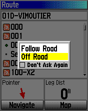
You are likely to know whether your Route was constructed for autorouting or direct routing (Follow and Off road in Garmin-speak) but even if you don't, this dialog means you can always just re-load the Route and choose the other option.  (Tip: do NOT tick the box saying "don't ask again"!)

If in the setup you choose one of the other options you lock the GPS to one mode or the other and if you get the 50 points message it doesn't offer you the get-out of using direct routing - all you can do is re-load the Route and hit the same 50 points message again, and I can understand that this would be a tad frustrating.
when you're dead you're done, so let the good times roll