Author Topic: Route points on Garmin eTrex Legend HCx  (Read 5650 times)

macthebike

  • I think therefor I am.
Route points on Garmin eTrex Legend HCx
« on: 08 March, 2012, 09:00:44 am »
My owner`s  Manual clearly states that it stores up to 250 points per route. However, when I download more than 50 points from  gpx files provided by generous Audax organisers, and reduce them down to 249 points(in Bikehike) the GIS always reports that it can only take 50.
                    So where does the 250 limit come in ?  I`m sure many other frustrated Garmin users must have met this one.......................Please help !

frankly frankie

  • I kid you not
    • Fuchsiaphile
Re: Route points on Garmin eTrex Legend HCx
« Reply #1 on: 08 March, 2012, 10:04:21 am »
There are two limits, the 50 point limit applies to autorouted routes.  (This is in the manual too, BTW - but not obvious)

In your GPS there is a setup option in Setup / Routing - to opt for 'Follow Road' (ie autoroute), or 'Off Road', or 'Prompted'.
If it is set to the first of these 3 options, your GPS will ALWAYS reject routes of more than 50 points.
I strongly recommend setting the GPS to 'prompted' and leaving it there, in this case your routes won't get rejected (instead you'll be asked if you want to switch to 'Off Road' mode).

In prompted mode, when you see this dialog:
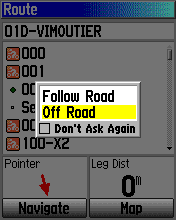
    <<  DON'T tick the tickbox!

[edit to add - either way these points limits are not a problem - if we take a 'day' or 200km ride as a benchmark, then if you are autorouting, 30 points would probably be enough, and if you use direct routing, 200 points would easily cover it.
NB if the 'route' you're downloading contains more than 200 points, it's probably best treated as a Track.]
when you're dead you're done, so let the good times roll

macthebike

  • I think therefor I am.
Re: Route points on Garmin eTrex Legend HCx
« Reply #2 on: 08 March, 2012, 11:13:53 am »
Hi Frankie,
Many thanks, it makes sense now. I have downloaded an 80km route with 50 points and pressed navigate/follow road and it drew onto the map on reaching 100%. I then did the same with a 200 km Audax and this was also a success. However on doing a second 200km route it calculated to 100%,but then just stuck at that,(with the word "drawing" still displayed), without drawing the route on the map. My only option was "cancel" so I repeated the "follow the road" with the same result. Have I hit some limit. ?

frankly frankie

  • I kid you not
    • Fuchsiaphile
Re: Route points on Garmin eTrex Legend HCx
« Reply #3 on: 08 March, 2012, 11:26:20 am »
I don't think so, it rather sounds as though it just gave up as 'too complicated'.  Also the longer distance, the more it will try to zoom out the map, making for a slower redraw.
[edit] also, if you do this (calculate a route) while you are at location A - and the route starts somewhere else location B - the GPS will be trying to calculate your route to the start as well ...
I'm not the expert here on autorouting, I don't usually use it.  If I do, it's usually small chunks of less than 50km at a time.  I'd suggest as a general rule, splitting any project into chunks of around 100km, or less.  In any case for 'events' (circular or out-and-back routes) this is a good idea, for other reasons.

What map have you got loaded?  A proper Garmin map will autoroute better than OSM see another current thread.
http://yacf.co.uk/forum/index.php?topic=55787.15
Planning a route on one map (eg Google Maps) and then using a different map in the GPS (Garmin or OSM) also complicates matters, for the calculation.
when you're dead you're done, so let the good times roll

macthebike

  • I think therefor I am.
Re: Route points on Garmin eTrex Legend HCx
« Reply #4 on: 08 March, 2012, 11:52:24 am »
I`ll split the failing 200 into 2 parts...I suppose some 200 s are more complex than others.
Yes, my GPS is on the cheap map(osm),so I take your point on that one.

I have till now been riding tracks, with max 500 pts and think they are great, except that the line is rather narrow and I`ve gone off route a few times, because of my poor old eyes. Hence the lure of the thick purple route line.

I think you have set me on the right track now and I do appreciate your help.
                                                                                                                           Mac       

frankly frankie

  • I kid you not
    • Fuchsiaphile
Re: Route points on Garmin eTrex Legend HCx
« Reply #5 on: 08 March, 2012, 12:24:58 pm »
Yes the dim 2x1 screen is certainly challenging on the eyes, I'm with you there!

Suggestion: don't use more points than you have to - less is more, when navigating a Route.
Less is more
when you're dead you're done, so let the good times roll

DaveJ

  • Happy days
Re: Route points on Garmin eTrex Legend HCx
« Reply #6 on: 11 March, 2012, 09:48:24 am »
If you are planning a Route on Mapsource, and then navigating it with autorouting on the eTrex, then more points is better.

If you don't tie the route down quite tightly, then the different algorithms on Mapsource and the eTrex will have you going down different roads to the ones you intended.

Dave

frankly frankie

  • I kid you not
    • Fuchsiaphile
Re: Route points on Garmin eTrex Legend HCx
« Reply #7 on: 11 March, 2012, 10:26:32 am »
Yebbut 50 points for 80km (as mentioned in an earlier post) is silly.
It'd be like having a mother-in-law on the handlebars.
when you're dead you're done, so let the good times roll

Re: Route points on Garmin eTrex Legend HCx
« Reply #8 on: 11 March, 2012, 05:07:12 pm »
For 200 km Audaxes I follow an approach I read of on these pages some time ago which is to place a "waypoint" on every routesheet instruction, but use off-road option for "navigation" (so not limited to 50 points).  Then set it up for "off-road transitions" so the unit beeps and the backlight comes on at every turn. Combined with a track drawn on bikehike, which helps to visualise the route on familiar OS symbology - you pretty much cannot go wrong.

For longer routes the 500 point limit on tracks means you lose too much resolution at complex junctions and in towns, so it may be best to chop the tracks up into sections.

I have tried the alternative of waypoint just on controls and a few intermediate points so that the route goes the right way on Mapsource, and then found the auto-routing on the eTrex (as DaveJ says) trying to send me the wrong way.

Re: Route points on Garmin eTrex Legend HCx
« Reply #9 on: 12 March, 2012, 04:37:37 pm »
I've been using a Legend for several years now, and thought I was pretty familiar with it.  But something happened last week that I've not seen before.  I had created a route for the Cheltenham New Flyer - I did this by loading the track provided by organiser Steve P into MemoryMap and then manually overlaying a route over it.  The total number of routepoints was well below 250.  But when I downloaded it to my Garmin (one operation, straight from MM to the Garmin, just like I've done many times before), it was transfered as two routes, one suffixed with "1", with that one having just the last half dozen or so routepoints in it.  I had no trouble navigating (I use "off-road") and just had to set navigation on the last section when I got to it, after Tetbury.

Has anyone else seen this happen?

frankly frankie

  • I kid you not
    • Fuchsiaphile
Re: Route points on Garmin eTrex Legend HCx
« Reply #10 on: 12 March, 2012, 05:51:17 pm »
Not here, but if it was a circular route it was highly intelligent behaviour.  It should be patented at once.
The '1' suffix indicates a duplication of some sort, obviously.
Possibly MM has a routepoint limit of its own, lower than 250?
when you're dead you're done, so let the good times roll

Re: Route points on Garmin eTrex Legend HCx
« Reply #11 on: 12 March, 2012, 06:43:22 pm »
It was not quite a circular route - I always either start a little way from the beginning, or finish before the end if the route to the finish is clear / familiar to avoid routing errors at the start.  The naming was just like M'soft's  where there is a duplicate file name, yes.  Not seen it before, and not aware of a limitation in MM.  Later on I'll have another look at the route and see if anything obvious shows up.

fuaran

  • rothair gasta
Re: Route points on Garmin eTrex Legend HCx
« Reply #12 on: 12 March, 2012, 06:48:06 pm »
Its a feature in Memory Map isn't yet? You can go to GPS menu -> GPS setup. Then you can set the GPS limits for waypoints per route and points per track etc.

Re: Route points on Garmin eTrex Legend HCx
« Reply #13 on: 12 March, 2012, 09:52:36 pm »
Its a feature in Memory Map isn't yet? You can go to GPS menu -> GPS setup. Then you can set the GPS limits for waypoints per route and points per track etc.
It would appear that you have hit the nail on the head!  I had to re-install Windows a couple of months ago, and all my software.  I guess I had previously set the waypoints/route at a higher number.  Now reset to 250.

Thanks fuaran

Re: Route points on Garmin eTrex Legend HCx
« Reply #14 on: 19 March, 2014, 09:11:24 am »
I thought I'd tag onto this rather than start a new topic.

I was looking at the route file for the Copdock Circuit. I couldn't be sure how many waypoints it had, as some software thought it was only a small number, but some saw 1300.

Looking in the file, I saw, for the first time I can remember, Garmin route point extensions. I had to Google to find out what they were. I understand the principle, though the advantage over standard points is not that obvious to me, but how will my (Vista) HCx handle these, if at all? I don't really want to find out on the event itself! I can try a transfer, but I still won't be confident.

Will I be able to use the route as it stands, because it only has 28 main points, or will (as I expect) the HCx see 1340 points and throw up its hands in horror? Oddly, it's Garmin MapSource that sees only the "main" points (the others are there, but not in the route list), and the independent Fugawi program that reports all of them and lets me edit any one (but of course generates files in which all 1300 points are "main" ones).

frankly frankie

  • I kid you not
    • Fuchsiaphile
Re: Route points on Garmin eTrex Legend HCx
« Reply #15 on: 19 March, 2014, 09:41:52 am »
If you mean the points that appear in the GPX as gpxx points - no the Vista HCx won't use them.  It will just use the 28 main points, and if it's set to follow road, it will just autoroute according to its own ideas between these points. 
[edit - though I note its a 100km - really 28 points is probably enough, the autorouting can't lead you far astray, with 1 point per 4km!]

If you import it into GPSies  http://www.gpsies.com/createTrack.do  (I offer this as neither BikeHike nor BRT seem to be working proparly at the moment) - you can then download it as a Track of 1351 points, which would need to be split into 3 for use in the Vista (easy to do in Mapsource), or as a simplified Track.  It may or may not be the correct roads, possibly not, GPSies has probably recalculated as well.

Oddly, it's Garmin MapSource that sees only the "main" points (the others are there, but not in the route list),

And if you look at the header of that GPX file you linked, it was in fact created in Mapsource. 
It's a file that is created as a Route in Mapsource with the autorouting turned on.  This autorouting information does not transfer to the Vista.  (I think the only model that really uses it properly is the Edge 705)

Even turning on the autorouting in your Mapsource and recalculating, won't guarantee the right route.
when you're dead you're done, so let the good times roll

Re: Route points on Garmin eTrex Legend HCx
« Reply #16 on: 19 March, 2014, 09:48:24 am »
Ah, all becomes suddenly clear. This is the solution for the "My GPS produced a completely different autoroute from the one I checked in MapSource, and now I'm heading down a motorway" problem ;D

Except that it was introduced because the HCx was the one that had the problem, so of course only later units have the solution.

Dithering down in GPSies last night produced rather a rough route. Real men write XML in Notepad*, so I've managed to split the file into the three stages between main controls manually, and I'll dither those down to 250 each in GPSies.

* Not from scratch, in my case anyway. Not enough knowledge.

frankly frankie

  • I kid you not
    • Fuchsiaphile
Re: Route points on Garmin eTrex Legend HCx
« Reply #17 on: 19 March, 2014, 10:00:31 am »
I edited my 1st reply - really, for a 100km, you don't need so many points.  A single 500-point Track would be fine, or just have the Track split into 3 without reduction.  Set them all to 'show on map' and it just looks like one Track.

A Route with more than 1 point per km would just be very annoying, IMHO.

GPSies - having given up on BikeRouteToaster, and now BikeHike, I tried Openrunner but didn't like it, but GPSies is not bad.  And it's been around for a long time, actually - at least 8 years.
when you're dead you're done, so let the good times roll

Re: Route points on Garmin eTrex Legend HCx
« Reply #18 on: 19 March, 2014, 10:36:25 am »
Thanks again - yes, I know it's a lot of points, but I didn't like the number of junctions that were basically bypassed when I reduced the number. I was thinking about the track alternative - may just do that.

Regards

Re: Route points on Garmin eTrex Legend HCx
« Reply #19 on: 19 March, 2014, 10:43:28 am »
When I used eTrex Legend Cx, I reduced the Waypoint count to TWO for each section of an Audax. The start and the finish.
On Mapsource, the routing would suggest a route with a pink line, and I would drag it until it agreed with the routesheet.
These intermediate points became Viapoints. Up to 10,000 total ??
After several iterations, the route generated on the handset would replicate Mapsource.

To get a realistic ETA for the section, ‘Vehicle’ needed to be Bicycle, and all the re-iterations and Viapoint additions were to force the route to use roads which Garmin had deemed unsuitable for bicycles.

After a few events, I got the hang of Garmin's logic and could reduce the number of iterations to 1 by populating Viapoints around major road junctions to give the handset no other option than to follow the Viapoint trail.

Re: Route points on Garmin eTrex Legend HCx
« Reply #20 on: 19 March, 2014, 10:58:45 am »
Now I need to know the difference between a viapoint and a Garmin route point extension...

(Of course, in this case, I'm using the organiser's file, rather than one I've created myself.)

frankly frankie

  • I kid you not
    • Fuchsiaphile
Re: Route points on Garmin eTrex Legend HCx
« Reply #21 on: 25 March, 2014, 08:59:02 am »
A Via point is Garmin's name for a Route point - that is, a point that is tagged in the gpx with a <rtept> tag.

In most software that has a 'Route' tool, using that tool creates Via points, through which the Route must pass.  There is no implication about what happens between those points, so by default it's a straight line.  They appear as black blobs in Mapsource.
(Edit to add - It's up to you and your GPS whether you choose to use this 'direct' approach or trust to luck the Garmin gods GPS autorouting, between these points.  It's not something to set up at the planning stage, for an Etrex.)

Garmin themselves use the name Route point to describe their proprietary Route point extension, which is tagged as <gpxx>.
Among desktop software, Mapsource can generate gpxx points if you use it in autorouting mode and then save the result. The points themselves are not visible, except as small kinks in the route when viewed very close up.  Some online planners generate gpxx points if that's what is specified as the output.  Otherwise they will generate Trackpoints, or Coursepoints, or Routepoints - it just depends what you specify at the export stage.
(Edit to add - not many Garmin models actually use this information - because older models pre-date this Garmin innovation, whilst newer models may use Courses which are Garmin's newer Big Idea, replacing gpxx.)

Fundamentally your problem (and not only you) is that the Organiser has made an effort but in the process made what the cricketing commentators would call A Right Horlicks of it.
when you're dead you're done, so let the good times roll

Kim

  • Timelord
    • Fediverse
Re: Route points on Garmin eTrex Legend HCx
« Reply #22 on: 25 March, 2014, 03:00:03 pm »
Edit to add - It's up to you and your GPS whether you choose to use this 'direct' approach or trust to luck the Garmin gods GPS autorouting, between these points.  It's not something to set up at the planning stage, for an Etrex.

Except of course that whether or not you intend to use autorouting will influence where you chose to put via points.  If you're going to be using straight-line 'off-road' navigation it's best to put them on or just after the junction at each turn.  If you're going to use autorouting, it's generally better to put them in the middle of sections of road you want to use, with occasional extras to discourage it from using a higher-weighted alternative.

Makes no difference to the software, but a lot in practicality.

frankly frankie

  • I kid you not
    • Fuchsiaphile
Re: Route points on Garmin eTrex Legend HCx
« Reply #23 on: 26 March, 2014, 08:40:50 am »
True.
when you're dead you're done, so let the good times roll