I've worked out how to do custom icons on the Garmin. The wrestling match with OSM Composer ran foul of the language barrier: I could blag my way around the program, but the German tooltips that appeared on the non-routable map, no, that didn't float my boat. Give it a while to get out of beta. Still, it showed srtm2osm, which is a neat tool for grabbing high-res contours from the NASA database to build into OSM-format (and hence into Garmin transparent overlay if you felt the urge).
This icon business is, of course, for bike shops, which OpenStreetMap defaults to either nothing, or the boring shopping-basket icon. Custom icons are full of fail, because with 32x32 and a full alpha channel to play with, I can see myself wasting huge swathes of time getting my maps just so.
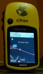
How-to: It's a two-stage thing. First, define a mkgmap style for the tags you want to use. That means that the map objects get marked with the correct Garmin TypeID. Shops are 2e, with the higher numbers unused, so 2e10 is bike shops (tag: shop=bicycle) to me.
Second, build a custom Typ-file (a Garmin binary that holds the colours and graphics) using the
online editor. The neat thing here is that if you define very little, the rest will appear as defaults, so it's quite hard to break it. It's very easy to make something hideously gaudy, mind! The typ-file styles all elements - land, ways and points - so at some point I'll start painting buildings and I'll colour the roads to match UK road signs, which is intuitively right to me.