Author Topic: Exporting files with POI's from memory Map to ride with gps  (Read 1636 times)

Exporting files with POI's from memory Map to ride with gps
« on: 16 August, 2014, 11:15:23 am »
I have  found  that inexperienced  riders  on my  Audax  rides using GPS easily  miss  controls.
I use  a  combination of  ride  with  GPS  for  routing  and  memory map  for  checking - an  OS !:50K is  very  useful.
I can add the  control points  as  marks  in Memory  Map, but how do I  export  a  GPS together  with  marks  as waypoints? 

Re: Exporting files with POI's from memory Map to ride with gps
« Reply #1 on: 16 August, 2014, 07:36:52 pm »
If you have the route (or track, or indeed both) in Memory Map and add the controls as marks, when you save the file it should contain everything that is displayed on your MM screen - route and /or track plus marks.  The user can then display what they want on their GPS.  It seems to me that marks only display at certain zoom levels on my Vista, and I haven't yet got to the bottom of this.  I'm sure it's covered somewhere in Francis's excellent words of wisdom.

Another way of dealing with this is to have separate tracks / routes for each section.  If riders then only display the "current" section of the ride the end of the line is a control!

frankly frankie

  • I kid you not
    • Fuchsiaphile
Re: Exporting files with POI's from memory Map to ride with gps
« Reply #2 on: 17 August, 2014, 11:58:43 am »
It seems to me that marks only display at certain zoom levels on my Vista

Menu > Menu > Setup > Map > [tab 3] > User Waypoints


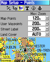
300m is probably a better setting - I tend to ride with the map more tightly zoomed in than I think most people do.  The trick really is to have 'User' points visible at a higher distance (say 2 steps higher) than 'Map' points, and then ride with your 'base' zoom setting somewhere between the two.
The next setup page [tab 4] allows you to tweak text sizes/visibility associated with these things.

Memory Map can be tricksy - its rather easy to export loads of stuff you don't want (from previous projects, possibly hundreds of miles away, that haven't been removed).  You have to either 'Delete All' before you start your project, or at least 'Hide All' and then just tick to show the bits associated with the current project, then when you export, 'Export Visible' (which doesn't mean 'what you can see on screen', it means 'what has been ticked').

A good trick with info controls is to make them 'proximity' points, which you can do in MM by setting a mark's 'Circle radius' (to say 200m) and choosing the option 'Proximity alarm'. 
You might also consider limiting the number of points in any Tracks you're using - like much other software, MM can do a good job of downsampling.
when you're dead you're done, so let the good times roll

Re: Exporting files with POI's from memory Map to ride with gps
« Reply #3 on: 17 August, 2014, 09:32:44 pm »
Thanks  for all the tips, useful one about proximity, markers did not understand  that  before.
Have now got all my  routes and  marks ordered into logically named categories in MM and  deleted all the  old junk, makes exporting a breeze. There was a lot of rubbish there - And it has  stopped  crashing!