Author Topic: Maximum waypoints in Etrex 20/30 route?  (Read 17276 times)

Maximum waypoints in Etrex 20/30 route?
« on: 25 November, 2012, 12:28:08 pm »
I know I should know this after having had my Etrex 20 for close on a year, but I've only done fairly simple routes so far.

How many waypoints can you have in a single route on the Etrex 20? I assume the 30 is the same.

I have searched on here - seems odd but I can't find info on this.

The spec on the Garmin web page just seems to quote total capacity on the device, not per route.

Apologies if the info is already here.

rogerzilla

  • When n+1 gets out of hand
Re: Maximum waypoints in Etrex 20/30 route?
« Reply #1 on: 25 November, 2012, 01:45:59 pm »
Try 250. That's the limit on a Legend.
Hard work sometimes pays off in the end, but laziness ALWAYS pays off NOW.

frankly frankie

  • I kid you not
    • Fuchsiaphile
Re: Maximum waypoints in Etrex 20/30 route?
« Reply #2 on: 26 November, 2012, 09:15:33 am »
Capacity is 50 Routes with a max of 250 points per Route (direct mode) or
50 points per Route (follow road / autorouting mode).

Same as the old Etrexes.  So (like those) there's probably an overall capacity of around 6000 routepoints (ie, less than 50x250).

Other limits (not strictly relevant to Routes, and unlikely to be a problem to anyone) are:
Waypoints 2000
Tracks 200 (I think) x 10,000 points.
when you're dead you're done, so let the good times roll

Euan Uzami

Re: Maximum waypoints in Etrex 20/30 route?
« Reply #3 on: 26 November, 2012, 10:26:40 am »
What's the total number of waypoints you can have (in total, not per route)?

Re: Maximum waypoints in Etrex 20/30 route?
« Reply #4 on: 26 November, 2012, 12:16:58 pm »
Many thanks Frankie - that would explain the occasional alert I remember about 50 - I quite often place a load of numbered waypoints into a route list and then ask the Etrex 20 to navigate between them, trusting that I've placed the waypoints to determine its choices.

Clearly with longer routes, particularly in the country, it's maybe better for me to place a waypoint at every turning point and navigate manually/directly between these so that I can use 250 - in some places that will surely get me a very long way.

thanks again

frankly frankie

  • I kid you not
    • Fuchsiaphile
Re: Maximum waypoints in Etrex 20/30 route?
« Reply #5 on: 26 November, 2012, 01:09:06 pm »
I reckon on typical UK lanes, it's pretty much broad as its long. 
Direct turn-by-turn routing would average around 1 point per km I reckon, so 250points will get you around 250km (very rough approximation).
Autorouting I might drop a point every 5km or so, to keep it on the roads I actually want to use.  50 points again pans out to about 250km.
Obviously in rural France, or mid-Wales etc, where the road network is not so crowded, you can go a lot further than this, either way.  Though the more sparse the roads, the less I would want to use autorouting (because the penalty is greater if when it goes wrong).

What's the total number of waypoints you can have (in total, not per route)?

As I wrote above, around 6000 routepoints, maybe a bit more.  These may or may not include up to 2000 Waypoints, which is Garmin's specified limit for the E20/30.  Bear in mind it's completely possible to create a Route using routepoints only (more correctly, 'via points'), without using any Waypoints (more correctly, 'User Waypoints').

FYI, I arrived at the 6000 figure by soak-testing an Etrex Legend HCx, ie just dumping in as many Routes, Waypoints, Tracks as it would carry.  I got to 36 Routes and 5160 routepoints before my patience ran out, it could still have taken more but I have reason to believe (from others who have tried a similar thing) it was fairly near its limit.
(An older much lower-spec Legend C maxed out at 2438 routepoints.)

In practice - I plan some pretty big multi-route, multi-week tours (mostly in France) - I've never exceeded 1400 points (over 15 days).
when you're dead you're done, so let the good times roll

Re: Maximum waypoints in Etrex 20/30 route?
« Reply #6 on: 09 May, 2013, 03:02:44 pm »
Direct turn-by-turn routing would average around 1 point per km I reckon, so 250points will get you around 250km (very rough approximation).
Autorouting I might drop a point every 5km or so, to keep it on the roads I actually want to use.  50 points again pans out to about 250km.

Apols, newbie Q here.

By "direct" routing do you mean selecting Off-Road after you've done Where To? and chosen a route (vs choosing the On Road by Time / Distance options)?

Pretty comfortable now with using MapSource to create waypoints, via points and plot routes. Just learning the ins and outs of using it when out on the bike, and experimenting between what you get in the different Route or Track following modes to see which I prefer.

TIA

-- Rob
The other Robw, not the wobbly one

frankly frankie

  • I kid you not
    • Fuchsiaphile
Re: Maximum waypoints in Etrex 20/30 route?
« Reply #7 on: 09 May, 2013, 07:13:14 pm »
Yes.

Garmin confusingly use the terms 'Off Road' and 'Follow Road' on their GPSs, whereas they use the terms 'Direct' and 'Autoroute' to mean the same things in their desktop software (Mapsource).

For Direct routing just 'joining the dots' turn-by-turn works pretty well, and results in an average density on UK lanes of about 1 point per km.  (In very rural areas such as mid-Wales, or central France, this could stretch out to 1 point per 5 to 10km on average, meaning a single Route could suffice for several days' cycling.)  Less is more - a common mistake IMO is to use too many points.

For Follow Road I think it works better to put the points between the junctions - ie just click on the roads you want to use, not the junctions you want to use.   Obviously you can take bigger bites so that any one pair of points will have 3, 4 or 5 junctions between them.  More than that is risky, IME, so with only 50 points possible that works out at 200-ish kms - again on typical UK lanes.  The more rural the route, the less inclined I would be to use autorouting - because the penalty when it goes wrong is greater, in terms of extra distance ridden.  OTOH in big unfamiliar towns it can be very useful.

But in either case for circular routes (which is what cyclists mostly do) you need to split a Route into 2 - 'out' and 'back'.
when you're dead you're done, so let the good times roll

Re: Maximum waypoints in Etrex 20/30 route?
« Reply #8 on: 09 May, 2013, 08:40:55 pm »


But in either case for circular routes (which is what cyclists mostly do) you need to split a Route into 2 - 'out' and 'back'.

Cool - I think I'm almost there in my understanding, including the Circular routes issue which I avoided by splitting on last test ride.

There's 3 things left bugging me - the first two of which I'm pretty sure can't be fixed, and one I'm not sure about:

  • Small text size of waypoint name in Next data field on Map
  • Making Route colour transparent, so an underlying track can be visible through it when navigating using Route
  • Have my "out" waypoints show up on return leg

The last one I need to play with. One idea was rather than the normal approach of waypoint just beyond the junction, would be to have them before. That way - the one with the turn instruction in it's name should appear before the one for the other direction. I only noticed this problem though when navigating with a track, I need to try it again following a Route - maybe it doesn't happen then.
The other Robw, not the wobbly one

Re: Maximum waypoints in Etrex 20/30 route?
« Reply #9 on: 10 May, 2013, 06:25:56 am »

Bear in mind it's completely possible to create a Route using routepoints only (more correctly, 'via points'), without using any Waypoints (more correctly, 'User Waypoints').

Sorry to be a bore Frankie but you are something of an expert on this - can you expand a bit on the dfference between "via points" and "waypoints/user waypoints" in a route?

How do they differ in the info they contain, how they show up on the map, max number you can have in a route etc etc?

Re: Maximum waypoints in Etrex 20/30 route?
« Reply #10 on: 10 May, 2013, 06:28:12 am »
[

There's 3 things left bugging me - the first two of which I'm pretty sure can't be fixed, and one I'm not sure about:

  • Small text size of waypoint name in Next data field on Map


There's a thread somewhere on your point 1 (possibly started by me) and I think with some useful info from Frankie and others.

I'll try to find it but you may get there first

edit: here, a further post of mine down the thread asks the question.

https://yacf.co.uk/forum/index.php?topic=54630.msg1112434#msg1112434

Re: Maximum waypoints in Etrex 20/30 route?
« Reply #11 on: 10 May, 2013, 07:41:06 am »
[

There's 3 things left bugging me - the first two of which I'm pretty sure can't be fixed, and one I'm not sure about:

  • Small text size of waypoint name in Next data field on Map


There's a thread somewhere on your point 1 (possibly started by me) and I think with some useful info from Frankie and others.

I'll try to find it buy you may get there first

edit: here, a further post of mine down the thread asks the question.

https://yacf.co.uk/forum/index.php?topic=54630.msg1112434#msg1112434

Thanks for that link. I was also going to try adding the Navigation field and see if that gave me a bigger version - seems like it might do which would be good news. Be a shame to lose the map space, but better than nothing.

I think the Comment instead of Waypoint name on the E30 was a bug that got "fixed" in a firmware update, which is a shame. Not sure if that applies to the Nav data field tho, maybe that can be made to show Comment. Will have an experiment.

- R
The other Robw, not the wobbly one

Re: Maximum waypoints in Etrex 20/30 route?
« Reply #12 on: 10 May, 2013, 08:46:37 am »
If you are a dab-hand at GoogleMaps, as in creating a DIY, try Tyre toTravel dotcom.
Configure it to Garmin and Walking.
Specify the start and finish. Pick/place the route to where you want it.
Create Waypoints where you want them along the route.
Bunch them up before, around and after motorway junctions and major road junctions. Spread them out down country lanes where there is little chance of the handset taking an alternative.

Save the route as a 'Garmin GP eXchange file' in a folder to copy to the handset.

PS Can someone with an eTrex 20 and OpenStreetMap check out 'Bicycle' routing along the A46 between Coventry and M42 Warwick Junction. Does the unit avoid this road or does it use it?

I can feel a pressie coming to me soon  ;D

frankly frankie

  • I kid you not
    • Fuchsiaphile
Re: Maximum waypoints in Etrex 20/30 route?
« Reply #13 on: 10 May, 2013, 09:09:24 am »
  • Small text size of waypoint name in Next data field on Map
  • Making Route colour transparent, so an underlying track can be visible through it when navigating using Route
  • Have my "out" waypoints show up on return leg

1.  Yes, this is the main reason why I've continued to buy older Vista models for my own GPS 'stable' rather than the E20/E30, even though the newer model is better in some ways.
2.  Again I think this may be something the older model does better.  The Track naturally sits on a layer above the Route, and the colours of each can be adjusted to give a good contrast.  I don't think you can change the Route colour on the E-types.  To be honest, having experimented with both the below, I generally prefer the default Magenta anyway.
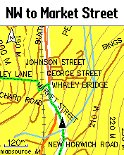
Green Track on White Route, or ...
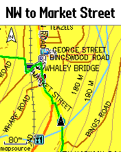
Green Track on invisible (actually yellow) Route (NB routing prompts still available).
3. Not sure I understand this one.  In Mapsource you can re-use waypoints and routepoints multiple times on different Routes, if you want.  This is one big advantage over most online planners, which only handle one route at a time.

can you expand a bit on the dfference between "via points" and "waypoints/user waypoints" in a route?

Really with modern high-capacity GPSs there's no practical difference, assuming you clear out all old points before each new project.
There is a storage limit for User Waypoints, and this used to be an issue when it was 500 (original Etrex Legend/Vista).  In the E20/30 the limit is 2000 and this is IME beyond any practical need - even a 2-week LeJoG using Direct turn-by-turn routing on minor roads only uses <1300 points.

When the limit of 500 was a problem, it was useful to know that by only using Via points in Routes instead of User Waypoints, you could store many more points (the limit is unspecified, but even on very old units it was over 2400 - on recent models certainly well over 5000).

Waypoints are created in software by using the 'Waypoint' tool and clicking anywhere on the map.  They can be information-rich with custom symbols, comment fields etc.
Via points are created by using the 'Route' tool and clicking sequentially on the map. Typically they inherit information from some underlying map point (or a pre-existing User Waypoint) and so can be relatively low-fat in themselves. 
It's this inheritance that can be slightly problematic (only at a theoretical level, really) when there's a map mismatch between the Planner and the GPS.
when you're dead you're done, so let the good times roll

vorsprung

  • Opposites Attract
    • Audaxing
Re: Maximum waypoints in Etrex 20/30 route?
« Reply #14 on: 10 May, 2013, 09:11:02 am »
I've decided to avoid this grief by just using a "track" and following the pretty line

Tracks can be annotated with waypoints, if you CBA

bikeroutetoaster.com can add waypoints to tracks *fairly* easily.  It has an annoying user interface for this. 

Not sure how the "tracks with waypoints" all works.  The map display can show next waypoint and distance to next waypoint.  It seems to use the track to find the distance.

Re: Maximum waypoints in Etrex 20/30 route?
« Reply #15 on: 10 May, 2013, 09:39:57 am »
I've decided to avoid this grief by just using a "track" and following the pretty line

Tracks also work fine on the eTrex 30 - but they don't give you the beep/prompt on each turn. I'm still experimenting with which I prefer.
The other Robw, not the wobbly one

Re: Maximum waypoints in Etrex 20/30 route?
« Reply #16 on: 10 May, 2013, 09:43:17 am »
3. Not sure I understand this one.  In Mapsource you can re-use waypoints and routepoints multiple times on different Routes, if you want.  This is one big advantage over most online planners, which only handle one route at a time.

Agreed - but if you have direction instructions in the Waypoint name (e.g. A09_L), you have to remember to reverse them on the way back and remember the numbers are counting down, and the L becomes R etc. Something I'm likely to forget in the small hours of the morning!

May not be an issue if I'm using routing with turn by turn - since the Guidance arrow on map tells me where to go. Haven't totally decided yet though whether I prefer routing by map or track.

It's probably not a big deal - I guess I'll find workable approaches.
The other Robw, not the wobbly one

Re: Maximum waypoints in Etrex 20/30 route?
« Reply #17 on: 10 May, 2013, 10:44:20 am »
I was minimalist when I used Garmins. 50 Waypoints for a 50 km section was a LARGE number.

This habit was born from using Metroguide many years ago. Metroguide didn’t support autorouting, so a Waypoint or Viapoint needed to be positioned several yards down the correct road after every junction. On occasions, a Waypoint or Viapoint needed to be placed on sharp turns in the road so the straight line looked correct to the road.
If there were more than 250 junctions and turns in the whole ride, the ride needed to be split.

A habit formed where a ride was split into sections and as few Waypoints as possible were used to successfully navigate the course.

When I got Topo GB with autorouting, even fewer Waypoints were needed to produce a successful Route.
I could usually get a section to contain less than forty points.

My enthusiasm for Garmins ended due to its inability to navigate AD HOC round Birmingham in a sensible manner. ‘Bicycle’ produced a ‘round the houses’ route and ‘Delivery Van’ used the M42, A38(M), M6 and M5.

Now there is OpenStreetMaps, I am interested to see a Garmin E20’s results for my ad hoc trips across Brum.

Kim

  • Timelord
    • Fediverse
Re: Maximum waypoints in Etrex 20/30 route?
« Reply #18 on: 10 May, 2013, 12:04:50 pm »
It doesn't matter what software you use, trips across Birmingham are always going to be miserable.

Re: Maximum waypoints in Etrex 20/30 route?
« Reply #19 on: 10 May, 2013, 12:07:12 pm »
It doesn't matter what software you use, trips across Birmingham are always going to be miserable.

Where's the damn "Like" button :)
The other Robw, not the wobbly one

Re: Maximum waypoints in Etrex 20/30 route?
« Reply #20 on: 10 May, 2013, 06:49:55 pm »
PS Can someone with an eTrex 20 and OpenStreetMap check out 'Bicycle' routing along the A46 between Coventry and M42 Warwick Junction. Does the unit avoid this road or does it use it?
My enthusiasm for Garmins ended due to its inability to navigate AD HOC round Birmingham in a sensible manner. ‘Bicycle’ produced a ‘round the houses’ route and ‘Delivery Van’ used the M42, A38(M), M6 and M5.
Now there is OpenStreetMaps, I am interested to see a Garmin E20’s results for my ad hoc trips across Brum.

Bear in mind that there are several different variants of OpenStreetmap, and the routing data in some of them (notably Velomap) has been fiddled with to a considerable extent.

frankly frankie

  • I kid you not
    • Fuchsiaphile
Re: Maximum waypoints in Etrex 20/30 route?
« Reply #21 on: 10 May, 2013, 06:52:44 pm »
3. Not sure I understand this one.  In Mapsource you can re-use waypoints and routepoints multiple times on different Routes, if you want.  This is one big advantage over most online planners, which only handle one route at a time.
Agreed - but if you have direction instructions in the Waypoint name (e.g. A09_L), you have to remember to reverse them on the way back and remember the numbers are counting down, and the L becomes R etc.

That's why I said "if you want"  ;)
Personally I like the mental exercise (such as it is) of translating the instructions coming back (and remembering not to convert LR and RL instructions) - same as I like converting miles to Kms and calculating road speed and ETA from signposts etc (I've never used a cyclecomputer).

I suppose (never tried this, but don't see why it wouldn't work) to have differently-named points on the same coordinates, using one on the way out and the other coming back, you could work up the out and back Routes as two separate Mapsource files (instead of one combined one) and import them into the GPS separately.
when you're dead you're done, so let the good times roll

Re: Maximum waypoints in Etrex 20/30 route?
« Reply #22 on: 12 May, 2013, 02:58:08 pm »
Oh and check the point count before loading them for an important ride  :facepalm:

Went to load up my Wells to Barton Mills route for yesterdays A&S audax, only for it to say limit for on road is 50, so did it in off road and got about 5 miles up the road until it stopped  :'(

Looking at it when I got home, it had 1700 points! Think it may have been one I did on mapometer before I learnt the error of my ways  ::-)

Re: Maximum waypoints in Etrex 20/30 route?
« Reply #23 on: 13 May, 2013, 09:20:03 pm »
3. Not sure I understand this one.  In Mapsource you can re-use waypoints and routepoints multiple times on different Routes, if you want.  This is one big advantage over most online planners, which only handle one route at a time.
Agreed - but if you have direction instructions in the Waypoint name (e.g. A09_L), you have to remember to reverse them on the way back and remember the numbers are counting down, and the L becomes R etc.

That's why I said "if you want"  ;)
Personally I like the mental exercise (such as it is) of translating the instructions coming back (and remembering not to convert LR and RL instructions) - same as I like converting miles to Kms and calculating road speed and ETA from signposts etc (I've never used a cyclecomputer).

I suppose (never tried this, but don't see why it wouldn't work) to have differently-named points on the same coordinates, using one on the way out and the other coming back, you could work up the out and back Routes as two separate Mapsource files (instead of one combined one) and import them into the GPS separately.

Have a go at creating a 'Garmin GP eXchange File' with Tyre toTravel dot com. When you have built your route and have the Waypoints all in the left hand Waypoints list, save that route, reverse the route, shift the waypoints to the other side of the junction ( or leave them where they are ) and then re-name them. save the reversed route as a different named Garmin GP eXchange File.

Re: Maximum waypoints in Etrex 20/30 route?
« Reply #24 on: 14 May, 2013, 07:39:37 am »
3. Not sure I understand this one.  In Mapsource you can re-use waypoints and routepoints multiple times on different Routes, if you want.  This is one big advantage over most online planners, which only handle one route at a time.
Agreed - but if you have direction instructions in the Waypoint name (e.g. A09_L), you have to remember to reverse them on the way back and remember the numbers are counting down, and the L becomes R etc.

That's why I said "if you want"  ;)
Personally I like the mental exercise (such as it is) of translating the instructions coming back (and remembering not to convert LR and RL instructions) - same as I like converting miles to Kms and calculating road speed and ETA from signposts etc (I've never used a cyclecomputer).

I suppose (never tried this, but don't see why it wouldn't work) to have differently-named points on the same coordinates, using one on the way out and the other coming back, you could work up the out and back Routes as two separate Mapsource files (instead of one combined one) and import them into the GPS separately.

Have a go at creating a 'Garmin GP eXchange File' with Tyre toTravel dot com. When you have built your route and have the Waypoints all in the left hand Waypoints list, save that route, reverse the route, shift the waypoints to the other side of the junction ( or leave them where they are ) and then re-name them. save the reversed route as a different named Garmin GP eXchange File.

I've done effectively that same process in MapSource.

It won't stop the "outbound" Waypoints showing up on the return leg - at least not in any way I can find. Waypoints are not part of a route or track on the device, they are freestanding - so even if not on the Route, I think they still show up in the Next prompt. They certainly do when following a Track, as noted above, still need to test when following as a Route.

It's not a deal breaker - I can just learn to ignore the ones that don't belong on teh current route. Or as suggested, only use one set of waypoints and mentally reverse them as an exercise to keep my brain awake!
The other Robw, not the wobbly one