Author Topic: New Etrex  (Read 31494 times)

Re: New Etrex
« Reply #125 on: 25 November, 2011, 07:19:36 pm »
This is a review of someone who bought a unit from GoOutdoors:

Quote
(I previously had the etrex vista) and decided to upgrade to this newer version.
Be warned, Garmin will force you to pay for all your mapping again, as only one map is
unlocked to one unit. Although this is tucked away in their T & C's, it has just cost me an
additional £140 to repurchase all my maps. I am now waiting a week for the DVD's to
arrive before the unit is fully functional. I feel as if Garmin have ripped me off as I only
bought the 2012 Europe map back in May when it was released, and less than 6 months
old it is rendered useless and I'm out of pocket.

I didn't realise this, so am holding back at the moment.

frankly frankie

  • I kid you not
    • Fuchsiaphile
Re: New Etrex
« Reply #126 on: 26 November, 2011, 09:29:31 am »
Garmin's locked maps are a well-known gotcha.  To be fair they're probably bound by their own licencing agreements with the map data suppliers. 

The real problem is that the maps seem expensive, and the reason for this is you are buying huge areas of mapping you'll never need.  In fact, per area and detail, the maps are incredibly good value.  But what is needed is an equivalent to the old "buy an OS sheet when you plan to go there" way of doing things.
when you're dead you're done, so let the good times roll

Re: New Etrex
« Reply #127 on: 26 November, 2011, 11:33:07 am »
As far as routable maps are concerned, that could change - the main providers were Navteq  - owned by Nokia, which Garmin use, and Tele Atlas, owned by TomTom. However, google are now doing their own routable stuff. My OH recently bought an HTC desire hd which she's been using over the last month as a satnav, and has found it pretty decent - admittedly without comparing it to other satnavs, but has also found it easy to use having not used one before. So Tele Atlas/Navteq *might* be under some pressure to drop licencing prices. But there's probably no getting away from the fact that decent off-road/walking map data is going to be from Ordnance Survey for the UK. Whilst I think they're pretty much self-funded, so need to maintain income, I wonder if there's scope for a more flexible payment form. Unfortunately, whilst Garmin are in the loop, I doubt that'll happen.

I think *my* main beef is less about pricing (well, that too, to a degree) but the maps either aren't device-locked (sd card, which isn't updateable afaia ?) or are.  It wouldn't be quite so bad if it allowed two devices to be supported, but then I guess their argument is you'd get people sharing licences.

Still, that's getting a bit off-topic I s'pose..


Richard Fairhurst

  • on the trail of the little blue stickers
Re: New Etrex
« Reply #128 on: 28 November, 2011, 10:12:33 pm »
But there's probably no getting away from the fact that decent off-road/walking map data is going to be from Ordnance Survey for the UK.
Or OpenStreetMap. :) I'm serious - have a look at OSM coverage of Evesham and pan west to Worcester, Malvern and the like. Really imprssive amount of footpath coverage - easily of Landranger quality. It's not nationally consistent yet, of course, but you can see which way the wind is blowing.
cycle.travel - maps and route-planner

Re: New Etrex
« Reply #129 on: 29 November, 2011, 11:43:29 am »
I don't entirely disagree - the few areas I've checked out on OSM vs OS look pretty comparable (and that was off-road stuff), so I've been more than happy to lob it onto my new Etrex..I'm certainly not in a hurry to buy maps from Garmin ;)
My comment was really in reference to pricing/licensing agreements - ie Garmin aren't going to be offering anything other than OS-based mapping because there isn't an altogether complete alternative.

I guess as OSM improves that might produce some squeezing of pricing, but it's still likely to lag behind OS.

Re: New Etrex
« Reply #130 on: 29 November, 2011, 05:53:43 pm »
Ordered the Etrex 20 from Go outdoors on Saturday.

They are still waiting to pick it apparently! - they sound kind of lost in the warehouse.

Got the discount highlighted in this thread - thanks folks.

Re: New Etrex
« Reply #131 on: 29 November, 2011, 06:53:48 pm »
Ordered the Etrex 20 from Go outdoors on Saturday.

They are still waiting to pick it apparently! - they sound kind of lost in the warehouse.

Got the discount highlighted in this thread - thanks folks.
Have you decided which maps to buy for it?

Re: New Etrex
« Reply #132 on: 29 November, 2011, 07:05:55 pm »
[
Have you decided which maps to buy for it?
No - will probably try and fiddle with OSM cycle. But the plan is to use it around Europe sometime so I was maybe thinking of Garmin City Navigator Europe as a back-up.

frankly frankie

  • I kid you not
    • Fuchsiaphile
Re: New Etrex
« Reply #133 on: 13 January, 2012, 01:15:18 pm »
Took me a while to find this.  I thought this display (available on some other models) had been lost in the E30 - but no, here it is.
Predictive profile (when following a Track).

when you're dead you're done, so let the good times roll

Re: New Etrex
« Reply #134 on: 14 January, 2012, 08:51:30 pm »
Took me a while to find this.  I thought this display (available on some other models) had been lost in the E30 - but no, here it is.
Predictive profile (when following a Track).

Absolutely amazing Francis!  As a new user, both to GPS and the E30, I am struggling with the seemingly infinite range of menus and options - I haven't dared put it on the bike yet, I'm quite enough of a hazard when walking round with it trying to find the right button :)

Could you briefly indicate your process (a) to get the planned track onto the machine in the first place (is this the same as a route??) and (b) split the screen with elevation above it?  Many thanks.

BTW for other newbies, there are a host of how-to-do-it GPS videos on youtube, including a couple I found last night of how to adjust the size of a scanned paper map by overlaying transparently on GoogleEarth so that it can then be downloaded into your GPS.

--
Bryn

frankly frankie

  • I kid you not
    • Fuchsiaphile
Re: New Etrex
« Reply #135 on: 15 January, 2012, 11:20:15 am »
Could you briefly indicate your process (a) to get the planned track onto the machine in the first place (is this the same as a route??) and (b) split the screen with elevation above it?  Many thanks.

I have to say it's more of a party piece than a practical display - I'd rather have a map with 2 data fields any day and you can't have all three at once (map, altitude plot, data fields) though you can have any 2 of those together ...

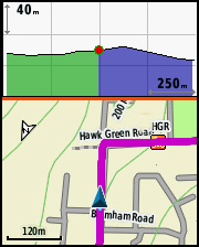
To answer (b) first - from the map screen go:
Menu* > Setup Map > Data Fields > Dashboard > Elevation Plot* ... and then Back* to return to the map page.
* 'Menu' is the l-h button.  * Elevation Plot is the bottom option, scroll down to see it.   * 'Back' is the top right button.

All 3 scales (map, and x and y axes) are independently adjustable.  To adjust the graph scales, go:
Menu > Elevation Plot > Menu > Adjust Zoom Ranges > waggle joystick to adjust > Back > Back to return to split map.


To answer (a).
To get the 'predictive' effect you would need a planned Track with elevation data included.  Typically this would simply be a Track that had been previously recorded on a GPS.   Otherwise you'd just see a flat line in the blue area above.
Drawing or autorouting a track in a planning aid such as Mapsource or some of the online services, generally results in a very good track (in terms of following the road) but no elevation info.  A few online services do include elevation, but I don't know which.
It is possible to add elevations to any 'dumb' GPX file using this online service http://www.gpsvisualizer.com/elevation where you simply upload the file and straightaway download a replica with elevations written in.  The result is a bit coarse but a lot better than nothing.

The Track, however it is derived, has to be saved out as a GPX file.   I then copy this into the [SD Card]\Garmin\GPX\ directory on the GPS.  For some reason, I have more success with files transferred onto the card, rather than direct onto the GPS itself - though in theory either should work equally well.

Then you simply use Where To? and choose Tracks then select your Track, to follow it in a navigational mode.  (NB if you just colour the Track and display it on the map, but don't use Where To? - again you won't get the predictive effect.  Or if you use data fields you won't get navigational hints.  Using Where To? with a Track is a more powerful way to do it on these newer models.)
when you're dead you're done, so let the good times roll

Re: New Etrex
« Reply #136 on: 15 January, 2012, 07:06:30 pm »
Many thanks, truly an impressive party piece. ;D

--
Bryn

Andrij

  • Андрій
  • Ερασιτεχνικός μισάνθρωπος
Re: New Etrex
« Reply #137 on: 13 February, 2012, 06:12:19 pm »
Does anyone know what the size limit, if any, is for the MicroSD card the 30 will take?  I haven't seen any reference to a maximum size, but I don't feel safe in assuming that equates to no limit.
;D  Andrij.  I pronounce you Complete and Utter GIT   :thumbsup:

tiermat

  • According to Jane, I'm a Unisex SpaceAdmin
Re: New Etrex
« Reply #138 on: 13 February, 2012, 07:07:21 pm »
Does anyone know what the size limit, if any, is for the MicroSD card the 30 will take?  I haven't seen any reference to a maximum size, but I don't feel safe in assuming that equates to no limit.

If the specs only say SD, then the limit is 2Gb (the limit for SD spec) if it says SDHC, then you are (usually) safe upto about 16Gb, although larger cards area available.
I feel like Captain Kirk, on a brand new planet every day, a little like King Kong on top of the Empire State

Andrij

  • Андрій
  • Ερασιτεχνικός μισάνθρωπος
Re: New Etrex
« Reply #139 on: 13 February, 2012, 07:39:43 pm »
;D  Andrij.  I pronounce you Complete and Utter GIT   :thumbsup:

Re: New Etrex
« Reply #140 on: 14 February, 2012, 11:51:26 am »
Ah, beat me to it. SDHC goes up to 32GB, SDXC handles up to 2TB - I've got a 16G Kingston in mine, since that seemed to be the price sweet-spot a few months ago.

Re: New Etrex
« Reply #141 on: 16 February, 2012, 10:31:26 pm »
Just got ETREX20 for £135 from BIKEINN.

I have two other GPS units both using the Garmin UK TOPO map. The licence allows for two units.

However I've loaded the openstreetmaps on to this new unit which covers UK.