I really don't know how you (anyone) can go wrong if you've got a GPS unless you constantly play with it, put it on the wrong screen, scroll around "to see what's coming up", forget to look at it or are too tired to realise that it's trying to help you.
Trying to navigate by following a green line on a cluttered map page that is locked to be "North Upwards" is a nightmare and means you'll end up getting confused at least once.
I create my route on bikely with one routepoint per instruction
*. The routepoints are directly on the junction, in the case of roundabouts I put the routepoint right on the road/roundabout junction of the exit I want. I also name the routepoint with the appropriate instruction.
For example:
Bicycle Path - FP300 2008 at Bikely.comZoom right in on Point 3 (C3 E2).
The route-sheet said Exit 2 (SP Town Centre) at this roundabout. The first exit is a works access road and wasn't shown as a normal exit on the RAB. If the waypoint was bang on the middle of the roundabout there'd still be some confusion. Instead my GPS was pointing me to that 3rd exit because that's where I'd put the waypoint. As I turned onto the roundabout facing what could be considered the 2nd exit (Templer Way) it was correctly pointing to the right down Chart Road.
I then put the GPS on this page:-
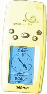
and leave it there. It has everything you need assuming you've programmed the route with proper care and attention. It shows:-
1) The direction arrow pointing to the next point.
2) The distance to the next point. (Mine also gives the expected time to get to the next point.)
3) The name of the next point, which is the instruction of what to do.
4) One other bit of info at the bottom.
If the arrow doesn't point roughly in the direction you're going then either the road bends round (in which case adding extra routepoints can help reduce this) or you've gone the wrong way, especially if the arrow is pointing backwards. Another clue is the "distance to next" going up instead of down.
The only times I've gone wrong using a GPS to navigate are:
1) When I've misprogrammed the route (happened a couple of times on the weekend's ride). Once I'd assumed the route was the same as the year before. Secondly I named a right turn "12 L" but it was obvious I'd done this. In each situation I had the routesheet as backup just in case.
2) When I've been too tired to remember to look at it. Don't rely on it warning you with a beep or a glowing screen. I've missed this on many occasions. Just get used to checking that the distance is counting down every 30 seconds or so.
3) When I thought I remembered the route and assumed the GPS was wrong.
4) Have a backup of a map and routesheet. Ro-Sham-Bo say Paper cover GPS.
* Routesheet implies that one exists. If you're creating your own route then:
1. At a minimum; place a routepoint wherever you change roads (i.e. you cross white lines).
2. Label them with instructions L/R/SO/E3/LiR (Left/Right/Straight On/Exit 3 at RAB/Left Immediate Right, etc).
2. Use various mapping pages (
Streetmap.co.uk gives you access to OS landranger maps of the entire country) and is better for working out road layout that google maps.
3. Use satellite pics to see the layout at junctions although remember they could be out of date.
4. Extra routepoints on long sections, or sections that change direction several times) are useful. After you've plotted the route look at the angle between a point and the next and compare it to the direction the road takes. If you think the arrow will be confusing then add a point to make sure.
For example, look at Point 18 of this route:
Bicycle Path - TO_BETH at Bikely.comWhen getting to that roundabout the arrow would be pointing South, but I wanted to go due East. The danger is that there is a little road going South which adds to the confusion. I knew I needed to go East at this point, but that's because I created the route and I've got a good (but still not perfect) memory.

For out-and-back style routes, or where the route uses the same bit of road more than once you must split it into separate routes so that no part of the route shares the same road(s). Otherwise the GPS will try and navigate you backwards to the finish rather than on the outwards part. The GPS will usually assume that you are further on in the route.
For example:
Bicycle Path - FP300 2008 at Bikely.comNear point 100 (the Hythe Control) the route doubles back and uses the same roads in West Hythe. This could have confused the GPS so I needed to split it. Although I created it all as one route, I split it into separate routes at Point 98/99 (which is why the prefix letter changes).
Loops can be done in one route if you know which way to go at the start to get you away from the confusing area.
Lots of other advice on jwo's GPS/Audax page:
Using GPS to navigate Audax Routes
