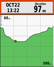
This question is an old chestnut and the point that is sometimes missed is that with the altimeter comes the 'Elevation Plot' page.
also
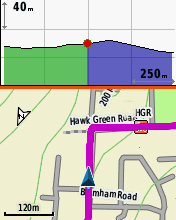
Although the altimeter itself is, like the compass, of dubious extra value, that page is quite nice to have especially when away on a long tour. It's good in 'live' mode, or to review the day's activity in the evening (as illustrated above), or to preview the next day's Track (if it has elevation encoded).
It's not available on the old non-barometric Legend, and I assume not on the E20.
[edit - apparently a wrong assumption - see Martin below]
[another edit to add 2nd screenshot showing a predictive view of profile following a Track]

