Author Topic: GPX file and Etrex 30  (Read 13254 times)

GPX file and Etrex 30
« on: 09 February, 2012, 10:41:55 pm »
Still languishing at the bottom of the learning curve here :)  Can now see where I have been and how slowly, and now am trying to plan, input, and activate a route.

I have a gpx file of a route created in Google Maps and converted by GPS Visualizer, sitting in the GPX folder of the Etrex30.

The Garmin Manual only refers to gpx files under geocaching,  so please excuse these basic questions.

Is the gpx file a route or a track, and will the Etrex still have the route turn information, or does that require a routable map in the Etrex?

Which menu option is needed to access the file to display the gpx route(?)/track(?) - route planner, track manager etc?   And once displayed, does anything else have to be done to start navigating with it?

Thanks

--
Bryn

frankly frankie

  • I kid you not
    • Fuchsiaphile
Re: GPX file and Etrex 30
« Reply #1 on: 10 February, 2012, 09:09:27 am »
If you can see it listed in Track Manager - its a Track.  If you can't - it's probably a Route. 

In Track Manager you can open it and colour it and set it to display on the map.  That is simple, but won't give you any prompts, but at least you can follow it as a guide - even without any basemap at all.

Really your 1-stop-shop is the 'Where To?' button. 
In here, if there is a route(s) available, it will offer a 'Routes' option, if there isn't, it won't.
In here, if there is a track(s) available, it will offer a 'Tracks' option, if there isn't, it won't.
Whatever you choose in the Where To? options, will give you navigation with prompts.

Most of the prompt information is generated from the map in use, so yes, by and large you do need a routable map.
when you're dead you're done, so let the good times roll

frankly frankie

  • I kid you not
    • Fuchsiaphile
Re: GPX file and Etrex 30
« Reply #2 on: 11 February, 2012, 10:05:23 am »
And once displayed, does anything else have to be done to start navigating with it?

To clarify - on the E30, to start navigating (ie with prompts) - and the ONLY way to start navigating - you go via the "Where To?" button.  (You don't need to do anything else, eg set to display on map etc - just this.)

This gives a submenu to choose between Waypoints (if available), Tracks (if available), Routes (if available), Map Points of Interest (eg stations, hospitals, restaurants etc) if available, User POIs if available.  Or you have an option to just point to somewhere on the map.

Availability of the first three depends on any GPX files that have been loaded into the GPS, availability of the Map Points obviously depends on the map installed.  (User POIS are as they say beyond the scope of this article.)

Choose any available item from these lists and then choose 'Go' to start navigating.  Simple and quick.

What happens next rather depends on your setup.  If you don't have a routable map installed, you will go straight into navigation mode, with an onscreen straight line to the point, or the start (or nearest point) of the Track or Route, that you have selected.  A Track, or a Route (in direct mode, the only option in this case) will work - sort of - even without a map.
If you do have a routable map installed, it will either go straight into navigation mode but this time a wiggly line following the roads, or - it will prompt you to choose one of three methods of navigation, like this:


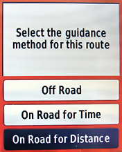
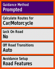
IMO it is greatly preferable to see this prompt and have this choice, and this is a setup thing - in Setup, Routing:


Tip: if you're having difficulty seeing your Track or Route GPX in the GPS, try loading it onto the SD card, not direct onto the GPS.  Same directory structure exactly, so [card]\Garmin\GPX\ .  Maybe it's just me, but I find this is more reliable.  You will find your tracks etc are rather 'sticky' though!  If you delete everything off the card - you'll find your old tracks and routes and waypoints are still there!  (Because they are cached in GPS memory.)  Very annoying.  You have to delete them via the GPS menus as well.
when you're dead you're done, so let the good times roll

Re: GPX file and Etrex 20
« Reply #3 on: 16 February, 2012, 10:49:11 pm »
I uploaded a route to my GPS, and then loaded another route with the same name.  I thought this would overwrite the first one, but no it produces another one of the same name.  So I have more than one route with the same name.  which  one is the latest and why does it hold duplicates.

Martin

Re: GPX file and Etrex 30
« Reply #4 on: 12 May, 2014, 09:12:51 pm »
Ok here I am with my shiny new etrex 30; got the map card (slightly warm unlocked City Nav) inserted done all the setup thingy; and uploaded a local track (via Mapsource it seems to work  :))

so I hit "Where to" and select the track; it shows it but says "Ready to Navigate"  ::-) do I actually have to be on the track for it to route me? in old money it would take me to the first point on the route and go from there..

other than that as you say FF a bit more limited than the old series but looks like it does the job  :thumbsup:

Re: GPX file and Etrex 30
« Reply #5 on: 13 May, 2014, 06:49:22 am »
Ok here I am with my shiny new etrex 30; got the map card (slightly warm unlocked City Nav) inserted done all the setup thingy; and uploaded a local track (via Mapsource it seems to work  :))

so I hit "Where to" and select the track; it shows it but says "Ready to Navigate"  ::-) do I actually have to be on the track for it to route me? in old money it would take me to the first point on the route and go from there..

other than that as you say FF a bit more limited than the old series but looks like it does the job  :thumbsup:

Do you still want £30 for yor old Vista?

Martin

Re: GPX file and Etrex 30
« Reply #6 on: 13 May, 2014, 08:04:29 am »
no sold it on ebay but the really old one is up for grabs

Martin

Re: GPX file and Etrex 30
« Reply #7 on: 14 May, 2014, 09:52:55 pm »
well; it will happily navigate anywhere but to the track; even though it's shown on the map  :-\ does it have to be a track that the device has seen before? if so that's pretty pants one reason I went for the 30 was to avoid pissing about with Mapsource to get the thing to guide me round a track that I had downloaded or been sent

Re: GPX file and Etrex 30
« Reply #8 on: 14 May, 2014, 11:50:29 pm »
A track is passive navigation. Set up your Etrex as FF's guidance. Display the track in your chosen colour. The cursor is where you are. Ride. The map and track scrolls under the cursor. When you see a junction coming up, glance at the Etrex, follow the track.

If you want audible warnings you need waypoints and stuff. Different thing.

Euan Uzami

Re: GPX file and Etrex 30
« Reply #9 on: 15 May, 2014, 08:29:01 am »
well; it will happily navigate anywhere but to the track; even though it's shown on the map  :-\ does it have to be a track that the device has seen before? if so that's pretty pants one reason I went for the 30 was to avoid pissing about with Mapsource to get the thing to guide me round a track that I had downloaded or been sent
you don't need map source for an etrex 30. Just drop files on it like it's a drive.

Martin

Re: GPX file and Etrex 30
« Reply #10 on: 15 May, 2014, 10:26:37 am »

If you want audible warnings you need waypoints and stuff. Different thing.

don't think so, I've got it to route turn by turn on a track, just can't remember how now; it was working on the train home but insisted on recalculating every 5 seconds  :(. Remember this is an etrex 30 not tho old vista etc series, I know they needed routes for turn by turn

Re: GPX file and Etrex 30
« Reply #11 on: 15 May, 2014, 10:32:33 am »

If you want audible warnings you need waypoints and stuff. Different thing.

don't think so, I've got it to route turn by turn on a track, just can't remember how now

I think that's on a track from the archive. I think you can fool it by putting a created track in there.

Dave_C

  • Trying to get rid of my belly... and failing!
Re: GPX file and Etrex 30
« Reply #12 on: 15 May, 2014, 10:40:41 am »
A track is passive navigation. Set up your Etrex as FF's guidance. Display the track in your chosen colour. The cursor is where you are. Ride. The map and track scrolls under the cursor. When you see a junction coming up, glance at the Etrex, follow the track.

If you want audible warnings you need waypoints and stuff. Different thing.

This is what I do ^^^

If I miss a turn its not dificult to pan out and find the line.

I have my GPX files on the microSD card in the following structure:

/GARMIN

- containing a directory ./GPX/ and the gmapsupp.img map file image

/GARMIN/GPX/routename.gpx file
------------------------------------------------------
to start the route off:

select 'Where To?' icon.
select 'Tracks' icon

lists:
'Current Track'
'Forth and Tay'
'Your track name'

click the track you want and you are taken to the map page with a large GO button on the foot of the screen. Click/press the joystick for select and you're on your way.

One thing I have found is if you have your data on your map page (speed/distance/trip/elevation) set to distance to destination, and you ride an alternate course, like our last ride which orgs gpx had us riding on the A93, we rode the south of the river road as its ultimately less busy, and my gps kept telling me I had ~130km to go when I only had 100km to go. It was or course trying to direct me back the way I'd come and back on track[/b

Dave C
@DaveCrampton < wot a twit.
http://veloviewer.com/athlete/421683/

Martin

Re: GPX file and Etrex 30
« Reply #13 on: 15 May, 2014, 10:45:05 am »
yep done all that the GO button just returns me to "Ready to Navigate" on the map (but shows the track in purple) but when I go back to "where to?" it tells me I'm navigating to the track  ???

I'm riding a real proper 100k track tonight I'll see what it says when I join it just down the road

Re: GPX file and Etrex 30
« Reply #14 on: 15 May, 2014, 12:37:53 pm »
If you are using GPX files constructed with Waypoints, make sure the total of all the Waypoints in all the GPXs add up to LESS than 2000.

Martin

Re: GPX file and Etrex 30
« Reply #15 on: 15 May, 2014, 01:44:58 pm »
If you are using GPX files constructed with Waypoints, make sure the total of all the Waypoints in all the GPXs add up to LESS than 2000.

do you mean waypoints or trackpoints? there are no waypoints in the tracks I'm trying to navigate to

Re: GPX file and Etrex 30
« Reply #16 on: 15 May, 2014, 02:19:08 pm »
It was a general comment to everyone because the title of the thread is 'GPX file and Etrex 30'.

There may be some who think EACH individual GPX file can have up to 2000 Waypoints with a maximum of 200 Routes as GPX files.  :thumbsup:

Dave_C

  • Trying to get rid of my belly... and failing!
Re: GPX file and Etrex 30
« Reply #17 on: 15 May, 2014, 04:16:22 pm »
If you are using GPX files constructed with Waypoints, make sure the total of all the Waypoints in all the GPXs add up to LESS than 2000.

I found gps routes longer than around 300km don't show fully on the screen. The reason is the number of way points. You can load the gpx file into bikeroutetoaster and reduce the number of way points to below the limit of th etrex (2000).
@DaveCrampton < wot a twit.
http://veloviewer.com/athlete/421683/

Re: GPX file and Etrex 30
« Reply #18 on: 16 May, 2014, 09:24:22 am »
Meriden 160 tomorrow.
Seven Routes, ( Two Controls and four INFOs ) each with less than twenty Wayponts.

Re: GPX file and Etrex 30
« Reply #19 on: 07 May, 2015, 10:16:02 am »
To get my Etrex 30 to give me turn by turn navigation which type of GPX file do I need to use: Route or Track?
LFCC

Kim

  • Timelord
    • Fediverse
Re: GPX file and Etrex 30
« Reply #20 on: 07 May, 2015, 12:33:10 pm »
Route.

Re: GPX file and Etrex 30
« Reply #21 on: 07 May, 2015, 01:12:36 pm »
In the eight years I owned a Garmin eTrex, I never loaded a GPX directly onto the unit.
A GPX file received from an Organiser was ignored and I plotted the route from the routesheet onto Mapsource.
I cleared all Routes and Waypoints off the unit and then from Mapsource, I sent Waypoints and Routes to the unit as a GDB file.

The Route on Mapsource needed to be tweaked and re-sent after seeing the unit plot strange paths between Viapoints.

Only in the last few months of ownership did I import GPX files onto Microsoft Autoroute 2011, edit the GPX and then construct a carbon copy manually on Mapsource.

Experience told me where to place Viapoints to get the unit plotting sensible paths.

What this procedure taught me was, 1/ Don’t trust a supplied GPX. 2/ By manually creating the route, I learned about tricky and important junctions.

The Edge 605 was happy with this process too.

Using Routes, the unit gave the turn-by-turn instructions.

Re: GPX file and Etrex 30
« Reply #22 on: 07 May, 2015, 05:50:52 pm »
I have now created a "GPX route"  (in GPSies), transferred it onto my Etrex and gone for a walk around the block following the big white arrows.  :)
Still have more questions:
  • I can only get the big white arrows to appear if I select "On Road" guidance but I am the restricted to 50 map points! Is there a way around this and still have the big white arrows?
  • How do I get the "Turn Warnings" to work? I have "Tones" on since every time I press a button the unit beeps and have selected tones 9 and10 for "Turn Warnings".


LFCC

Kim

  • Timelord
    • Fediverse
Re: GPX file and Etrex 30
« Reply #23 on: 07 May, 2015, 05:55:28 pm »
  • I can only get the big white arrows to appear if I select "On Road" guidance but I am the restricted to 50 map points! Is there a way around this and still have the big white arrows?

Create multiple routes.

50 points should be sufficient for 200km in most circumstances, if you put the points in sensible places.

Multiple routes for circular rides are a good idea anyway, so it doesn't think you're on the way back to the finish prematurely.

Re: GPX file and Etrex 30
« Reply #24 on: 07 May, 2015, 06:22:54 pm »
Thanks Kim.
GPsies has allowed me to reduce the GPX route to 45 points. Not sure why it won't allow 50

Anyone got any ideas how to get the turn warnings to work?
LFCC