Author Topic: Altitude measurement - who to believe!  (Read 11719 times)

Re: Altitude measurement - who to believe!
« Reply #25 on: 25 March, 2009, 02:35:50 pm »
So did I. By riding 100 laps of the old Eastway cycle circuit with an Edge 305... Accuracy of Elevation Measurement Using GPS
Quote
On the Edge 305 at least, there is no measureable 'spike' in elevation caused by a cold start of the device. Assuming no manual calibration of the barometer is made, it should be possible to record elevation as soon as the GPS is turned on.
The accuracy of elevation recording is dependent on good sky views from the GPS. Routes that travel though wooded areas or steep sided valleys are likey to contain more spurious spikes than indicated by this experiment. To assess elevation accurately, it is necessary to graph the profile in order to identify these spikes

The lack of an initial spike caused by cold start may just mean that the air pressure hadn't changed since the 305 last calibrated itself. Did you log the ride to Eastway, then turn it off/on to clear the track log?
However it could also mean that the 305 logs GPS height to the track log rather than barometric height. Why would leaning the bike against a building cause a spike in a barometric trace? Why would poor sky views affect the accuracy of an elevation recording from a barometer? It's more likely that a bit of wind buffet would give the odd small spike.

Also when considering the effect of barometer drift on height gain, it's only drift that occurs between the bottom and top of a particular climbing section that will get included into height gain totals. If the software is set to allow for a bit if fluctuation by only including climbs of more than a couple of metres in the total, this could mean that drift has no effect.
In some weather conditions the air pressure can remain stable for quite long periods. One year I did a 1:25,000 contour count for the Corker, reinforced with the spot heights off 1:2500 maps, and then did the ride using a barometric altimeter (Ciclomaster CM414). The reported altitude was spot on for the first 3 or 4 hours, and was still only 3m high when I got home some 14h later. The reported height gain was in between Sean's official figure (1:50000 contour count?) and mine.

red marley

Re: Altitude measurement - who to believe!
« Reply #26 on: 25 March, 2009, 03:20:33 pm »
In that particular experiment, I turned the GPS on at the Eastway. The previous time it had been on and receiving a satellite signal was several months previously a couple of hundred miles away.

The Garmin GPS units that have a barometric altimeter must use both the GPS height and some barometric measurements when logging elevation. I have not seen any documentation that describes how exactly how the two measurements are combined by the device, but I would be surprised if the GPS spikes were caused by wind gusts. That was the only significant erroneous spike and was the only time in 6 hours where the device didn't have a good sky view. Equally a cycle-specific device that was vulnerable to gusts of wind would seem rather less than useless to me.

And yes, barometric gain has minimal effect on the 'figure climbed' total. That was the point I was trying to make on that page. An erroneous slow change in height of 20m over a day has a negligible effect on a climbing figure that is likely to be thousands of metres.

andym

  • Expat Cyclist
    • AndysRockets
Re: Altitude measurement - who to believe!
« Reply #27 on: 25 March, 2009, 06:00:50 pm »
Also need to take into account the sampling intervals.  eg 1 per second, 1 per 10s, intelligent/auto setting etc.

If you say do an out and back route up a steep hill, then back down again, you'd probably expect a symmetric elevation profile if plotted vs distance.  But if the sampling is say 1 per 10 seconds, you'll have a lot more datapoints for the way up and hence better terrain resolution, than on the way down which would "smooth out" the little ups/downs (assuming you go downhill on a bike much faster than uphill).  If the GPS (or software) is just adding all the +/- deltas between each point, you'd potentially get quite a difference between the up and the down track logs.
AndyM

Re: Altitude measurement - who to believe!
« Reply #28 on: 25 March, 2009, 07:44:47 pm »
I've got some profile plots (not here, they're on my work laptop along with the raw GPX files) that show the GPS recording reasonably different1 profiles for the same hills on subsequent laps of the same 10.6km route (Richmond Park). No barometric altimeter either, just a bog standard Garmin eTrex and sometimes a Garmin Forerunner 405 too.

It's a pretty good indication of the combination of the inherent GPS error (i.e. maximum 4m accuracy) and the smoothing algorithm the GPS applies when it tries to make sense of the readings.

All of these are logged at 1 point per second (in the case of the eTrex), so there is unlikely to be more than a 0.5m elevation change up or 1.5m down (given 20kph up a 10% hill or 60kph down it) between any two points.

1. To qualify this; different peak/nadir heights and visibly different (to the human eye at least) profiles of the same hills.
"Yes please" said Squirrel "biscuits are our favourite things."

TimC

  • Old blerk sometimes onabike.
Re: Altitude measurement - who to believe!
« Reply #29 on: 26 March, 2009, 09:49:04 am »
There's some interesting data here, and I don't doubt the amount of effort that's gone into collecting it! The original question was which of the various cumulative height measurements to trust, though there was no statement of the accuracy required. I presume that the question is simply out of interest as, I assume, nothing of any moment is likely to hinge on the answer? Though, as you guys seem all to be Audax specialists, perhaps some element of your competitions and/or statistical merit relies on this data? Forgive me; I'm not familiar with the inner workings of the discipline.

jwo's interesting experimant round Eastway with the Edge 305 (I have both this and the 705) shows the degree of scatter to which I referred, and the 10-lap sample graphic shows how much the recorded profile may vary. The error in cumulative altitude gained/lost will depend on the way the data is collated within the device, and whether it is 'smoothed' by before the report is given. If it is simply an arithmetic summing of the difference between each recorded point, jwo's lap data shows that very different figures could be achieved for each lap.

As for the Tracklogs/MemoryMap data; yes, it is calculated on a elevation grid which allows significant areas of uncertainty - and the cliffside or bridge examples mentioned above would introduce further errors. However, the data derived from a given route is repeatable and won't vary with time or device, and probably therefore produces a more useful figure for later comparison or assessment. At the end of the day, how accurate do you need to be? Short of surveying the route inch by inch and using jwo's technique of repetition to average out errors, you will have to accept the innacuracies inherent in either the map grid or the GPS/barometrics you use. For the purposes of consistency, I'd go with the mapping software.

As for relying on any of this for landing in foggy weather - we don't use either GPS or barometric information for that! We use short-range radar and radio devices (radio/radar altimeter and Instrument Landing System) which measure distance and deviation in real time and to very small tolerances. GPS and barometrics are simply too inaccurate!

Re: Altitude measurement - who to believe!
« Reply #30 on: 26 March, 2009, 10:46:01 am »
As for the Tracklogs/MemoryMap data; yes, it is calculated on a elevation grid which allows significant areas of uncertainty - and the cliffside or bridge examples mentioned above would introduce further errors. However, the data derived from a given route is repeatable and won't vary with time or device, and probably therefore produces a more useful figure for later comparison or assessment. At the end of the day, how accurate do you need to be? Short of surveying the route inch by inch and using jwo's technique of repetition to average out errors, you will have to accept the innacuracies inherent in either the map grid or the GPS/barometrics you use. For the purposes of consistency, I'd go with the mapping software.

But the point is that it's not consistent for different routes. It doesn't matter that it consistently gives the same answer for a specific route, if that info is just wrong. For the same route it will always report the same right (or woefully wrong) value, but two roads 200m apart going over roughly the same terrain could have completely different climbing figures.

The DEM data for the Canonbie to Dalkeith leg of LEL gave a climbing figure of 2324m. That's wrong by at least 50% (the real figure is below 1500m).

When you say "How accurate do you need to be?" I'd say that I need something much better than a possible error of 50%.

Altitude measurement from GPS tracklogs is still tricky, they still need appropriate algorithms to smooth out the profiles, but there's no great surprise given the fact that each point logged has a possible error of +/- 4m (at best accuracy).

Take jwo's Eastway example. Over 100 laps adding up the elevation changes you can see you'll get a pretty accurate figure for the total elevation gain. To put it another way, with the data for all 100 laps create a single guess at the profile for a single lap, calculate the gain in that lap and then multiply by 100. It's going to be reasonably close to the real figure.

With the DEM version you get the one profile for one guess at the lap. This could be anything based on what the DEM data looks like at that spot. It could, theoretically, be completely flat. 100 laps * 0m = 0m elevation gain. It could, theoretically, give 50m gain over the lap, giving 5000m climbing for 100 laps. And, of course, it could produce roughly the right elevation gain per lap of 30m, giving 3000m climbing for 100 laps. But there's no guarantee it would do this, and any spurious value it produces is just multiplied to give a meaningless figure.
"Yes please" said Squirrel "biscuits are our favourite things."

TimC

  • Old blerk sometimes onabike.
Re: Altitude measurement - who to believe!
« Reply #31 on: 26 March, 2009, 12:37:00 pm »
The DEM data for the Canonbie to Dalkeith leg of LEL gave a climbing figure of 2324m. That's wrong by at least 50% (the real figure is below 1500m).

When you say "How accurate do you need to be?" I'd say that I need something much better than a possible error of 50%.

Altitude measurement from GPS tracklogs is still tricky, they still need appropriate algorithms to smooth out the profiles, but there's no great surprise given the fact that each point logged has a possible error of +/- 4m (at best accuracy).

Take jwo's Eastway example. Over 100 laps adding up the elevation changes you can see you'll get a pretty accurate figure for the total elevation gain. To put it another way, with the data for all 100 laps create a single guess at the profile for a single lap, calculate the gain in that lap and then multiply by 100. It's going to be reasonably close to the real figure.

With the DEM version you get the one profile for one guess at the lap. This could be anything based on what the DEM data looks like at that spot. It could, theoretically, be completely flat. 100 laps * 0m = 0m elevation gain. It could, theoretically, give 50m gain over the lap, giving 5000m climbing for 100 laps. And, of course, it could produce roughly the right elevation gain per lap of 30m, giving 3000m climbing for 100 laps. But there's no guarantee it would do this, and any spurious value it produces is just multiplied to give a meaningless figure.

Interesting problem! The more you go into it, the more issues get raised.

On the Eastway log: I assume that jwo used the 305's lap function to delineate the start of each lap in order to make it easy to overlay and compare the data. Doing so effectively eliminates errors accumulated in each previous lap so that each lap can be treated on its own. As he says, the average elevation gain in each lap was (IIRC) 29.5m; summed over 100 laps gives 2950m, which is probably pretty close to the reality as the calculation method effectively eliminates errors each lap. Had there been no discreet lap delineation, the errors would have accumulated over the whole 100-lap distance and may have given a very different overall (and thus average) figure - and directly comparable to your DEM example given in your last paragraph.

I've been back through various of my rides over the last five years or so. I often ride one of a number of shortish circular routes locally, so I have several GPS logs of each route. The total ascent figure given for each iteration of each circuit varies by up to 20%, though most are within 5% of the average (though earlier logs from a Forerunner 201 vary more greatly). The terrain locally is smoothly rolling countryside with nothing above 350ft elevation, and gradients rarely more than 5%. There aren't many sections of my routes that are heavily overhung by trees, and all of them are rural so buildings aren't an issue. The variation in reported elevation gain became an annoyance to me when logging rides online, and so I elected to use the MemoryMap figure I derived for each route. From your contentions it may well be that that figure is equally inaccurate, I suppose, but at least it's the same each time!

If you really feel you need an accurate figure, and you aren't satisfied with the methods currently at your disposal, I guess you could find a barometric device which is adjustable for varying sea-level pressure, contains a vibrator to eliminate stiction in the capsule, and records an elevation trace with totaliser function. Competition gliders used to carry such a thing, though the ones I remember from 30+ years ago would hardly be practicable on a bike! Maybe modern ones are more portable?

Jaded

  • The Codfather
  • Formerly known as Jaded
Re: Altitude measurement - who to believe!
« Reply #32 on: 26 March, 2009, 01:00:42 pm »
Hot Air Balloon pilots often have an altitude barometer.

I'll see if I can borrow one and done some comparisons GPS vs HAB altimeter vs mapping.

Probably later in the summer.  :)
It is simpler than it looks.

TimC

  • Old blerk sometimes onabike.
Re: Altitude measurement - who to believe!
« Reply #33 on: 26 March, 2009, 01:09:15 pm »
Make sure you disconnect the HAB first! ;D

Re: Altitude measurement - who to believe!
« Reply #34 on: 26 March, 2009, 01:36:24 pm »
I'm not saying that GPS tracklogs, and elevation gains derived from them, are wonderfully accurate. After all, they work by averaging and smoothing data containing a relatively large error component.

Given a set of values, recorded at 1 second intervals with a possible error of 4m on each value there's no way to know whether a series like this:-

0m, 0m, 0m, 0m, 0m could represent something perfectly flat or something that undulates as 0m, 4m, -4m, 4m, 0m, or vice versa.

What you can do though, with reasonable accuracy, is fine the peak/nadir of each hill with relatively good accuracy and calculate the size of the major climbs. If each point has a possible 4m error then 16m total error (top+bottom) on a climb of 300m is not bad.

I joined in this thread to refute the claim that Memory-Map/Tracklogs altitude measurements were trustworthy when they are easily demonstrated not to be, and also to point out that GPS elevation plots shouldn't be taken as truth either, as they are also inherently flawed.

As I said, I'm building up a log of laps of Richmond Park logged at 1 trackpoint per second. Here's an example of a profile plot of 3 laps (plus a short ride to/from the park):-
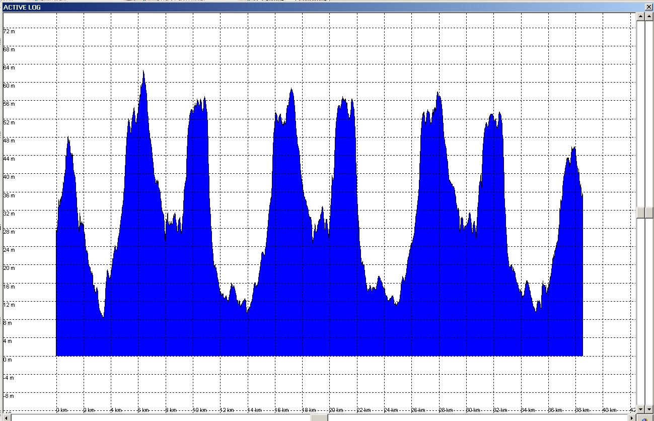


(The lap starts at about 3.75km in and each lap is 10.67km long.)

It's immediately obvious that there are differences between each of the 3 laps, despite it being exactly the same route each time.

I intend to take these GPX logs and produce a plot of the profile of a lap. Since there's no guarantee that I'll get a point at exactly the same place each time I'm going to rely on the fact that it's a circular route. I pick a single point in the centre of the park and, for each point in the GPX file, calculate a bearing to this point from the central point. I then plot GPX elevation against bearing (0 to 359 degrees). Once I'm plotted all 100 laps I can calculate a best guess at the true profile of the lap and then work out the climbing.

Quote
From your contentions it may well be that that figure is equally inaccurate, I suppose, but at least it's the same each time!

True, but for a specific route there is one true figure for climbing.

I would expect that, if repeated enough times, the figure from a GPS being +/- 4m accuracy for a specific point, would average out to roughly the right number. There are other factors at play as you point out (tree cover, buildings reflecting signals, etc). However, this is just a single point.

Where GPS tracklog analysers fail is there calculation of ascent. If you take every reading as truth then you get insanely over-rated climbing figures, especially if the trackpoints are logged at a high frequency. Garmin Training Centre gives me ~250m of climb for my commute which is pretty much flat alongside the Thames. There's probably 20m of climb on the way in (Putney Bridge and Lambeth Bridge) and 40m on the way home (I live about 25m ASL, work is 3m ASL).

I'm trying to write something that makes a better effort at picking out the peaks/troughs of climbs and calculates the differences between these two, ignoring any minor glitches on the way up. Ideally you'd feed it a GPX tracklog and it would spit out a figure more inline with proper climbing. Eventually I want it to generated an expanded profile plot annotated with the appropriate lines for peaks/troughs so you can see what it has included, and what it has ignored.
"Yes please" said Squirrel "biscuits are our favourite things."

TimC

  • Old blerk sometimes onabike.
Re: Altitude measurement - who to believe!
« Reply #35 on: 26 March, 2009, 01:45:00 pm »
That's an awful lot of effort to go to to get an accurate figure for just one ride! Working out a system which picks the highest and lowest points of each significant climb, filters out the noise, and then gives a cumulative figure for total ascent may well work though. Good luck with that. Most of the rest of us, I suspect, will put up with what we've got for now, and will gratefully accept the improvements as both GPS firmware and mapping software get more accurate!

Re: Altitude measurement - who to believe!
« Reply #36 on: 26 March, 2009, 02:04:21 pm »
That's an awful lot of effort to go to to get an accurate figure for just one ride! Working out a system which picks the highest and lowest points of each significant climb, filters out the noise, and then gives a cumulative figure for total ascent may well work though. Good luck with that. Most of the rest of us, I suspect, will put up with what we've got for now, and will gratefully accept the improvements as both GPS firmware and mapping software get more accurate!

There are several reasons for doing it.

1) It means I do 100 laps of Richmond Park this year. That's 1000km of undulating training riding. :)
2) What I learn from doing this should help me further understand what constitutes "climbing" (see below).
3) I'm a maths and computing geek. A bit of 3D geometry adds to the "fun", plus some graphing and other algorithmic goodness.

I know a lap of RP is "about 75m" climbing. By inspection:-

Start at 10m, climb to 58m, drop to 26m, climb to 32m, drop to 27m, climb to 54m, drop to 12m, climb to 16m, drop to 10m.

That's 48 + 6 + 27 + 4 = 85m. The two major climbs are very noticable. At a fast enough speed the 6m climb (just past Ham Gate going anti-clockwise) is pretty much swallowed up by momentum. The 4m climb along the final straight is very slight, but it's not something that momentum can take you up. This are the bits that need to be taken into account. A 6m climb is mitigated by momentum after just haring down the back straight, but a 4m climb will count because it's preceeded by a long stretch of flat rather than just after a downhill section.

I'd love to have 100 laps of my DIY 200 up to Cambridge and back, however, that's going to take a while, it'll get rather boring, and I don't always take the same route every time. Richmond Park is nearby, easy to get to, fun to cycle round and 100 laps can be chipped away at slowly and surely.

In "The Hour" Hutch mentions that he logged over 500 laps of RP in one seasons training!
"Yes please" said Squirrel "biscuits are our favourite things."

TimC

  • Old blerk sometimes onabike.
Re: Altitude measurement - who to believe!
« Reply #37 on: 26 March, 2009, 02:18:59 pm »
I must try RP sometime, but it's not very local! ISTR a debate about speed limits there not so long ago, and their application to bicycles. Wasn't it 20mph? I'm sure you stick to that... ;)

Re: Altitude measurement - who to believe!
« Reply #38 on: 26 March, 2009, 02:29:13 pm »
I must try RP sometime, but it's not very local! ISTR a debate about speed limits there not so long ago, and their application to bicycles. Wasn't it 20mph? I'm sure you stick to that... ;)

Of course not, but then I avoid the park at busy times, often going in at night where the cars are locked out and there are no Police about with speed guns.
"Yes please" said Squirrel "biscuits are our favourite things."

frankly frankie

  • I kid you not
    • Fuchsiaphile
Re: Altitude measurement - who to believe!
« Reply #39 on: 27 March, 2009, 10:09:12 am »
Quite interesting discussion.  Some more altigraphs for you ...

This is a section of the climb out of Aberystwyth up Plynlimon, travelling left to right west to east.
Its a very steady 'choose a gear and stick to it' kind of a climb.

The first plot is the GPS recorded altitudes (non-barometric), the recording was set on the defaults, which I think work very well for most purposes (though not for this). 

Note the 'flat' at about 11km - this was a short wooded section of road (marked at left end of map).
The summit is at the viewpoint on the map.
Note the obvious poor track quality on the descent, where the default recording settings just obviously aren't frequent enough (and possibly the sky view wasn't great either).

Next plot - the same track but using the DEM in Memory Map.

Note the apparent jaggies in the km or so before the summit.  These just don't exist on the road (or in the first plot) and the map shows that the road has been engineered along this section to give a steady gradient - the DEM doesn't take such engineering into account, apparently.  Note also the sharp dip at the bridge just before 18km (right end of map) again not shown on the GPS.  Here I suspect the truth is somewhere between the two!
I also find the shape of the summit a lot less convincing than in the first plot.
The graph of the descent however is obviously much better.

Finally, I derived a track from Google Maps for the same section of road, and dumped it into Memory Map and this plot uses the DEM again.  I was expecting this to give the best results of all - because I find that Google Maps tracks sit very accurately along the road in a 1:25,000 OS map - more accurate than a GPS track, sometimes.

Disappointingly, almost no difference.  I was expecting some jaggies to have gone from this version (which if they had, would have indicated the GPS track wandering off-line in rugged areas).
when you're dead you're done, so let the good times roll

Re: Altitude measurement - who to believe!
« Reply #40 on: 27 March, 2009, 02:16:28 pm »
What fun!

The Cotswold Corker, start to Guiting checkpoint (barometric GPS set in Gloucester)
GPS profile above, MemoryMap DTM profile below

Checking such detailed maps as I have access to,
km.......map htgps htdtm htwhere
0485048start
4.8250257233top of Bushcombe Lane, 400m before B4632
8.4949099dip before Winchcombe
8.710198101Winchcombe
9.4828084dip after turning off Winchcombe High Street
12.7299303295top of Sudeley hill
14.0254253257spot ht in dip
14.6 266 268 262 top of rise
15.8195190196crossroads in dip before Guiting
16.5 213 212 218 top of rise
18.3 163 156 159 checkpoint

The DTM version seems to be smoothing out some of the minor dips, and has cut off the top of the first rise, probably because that section has a steep dip just off to the right

TimC

  • Old blerk sometimes onabike.
Re: Altitude measurement - who to believe!
« Reply #41 on: 27 March, 2009, 02:51:51 pm »
What graphing program are you guys using?

inc

Re: Altitude measurement - who to believe!
« Reply #42 on: 27 March, 2009, 05:43:31 pm »
This isn't what they are using but is quite useful as it is Java and runs on any system and is free.

GPS Altitude Chart - Screenshots

frankly frankie

  • I kid you not
    • Fuchsiaphile
Re: Altitude measurement - who to believe!
« Reply #43 on: 27 March, 2009, 05:56:14 pm »
What graphing program are you guys using?

That's just the inbuilt tool in Memory Map.
when you're dead you're done, so let the good times roll

TimC

  • Old blerk sometimes onabike.
Re: Altitude measurement - who to believe!
« Reply #44 on: 29 March, 2009, 04:59:50 am »
OK, I didn't know you could import a GPS track into MM and have it graph the GPS elevation profile - I'll have to try that! :thumbsup:

Re: Altitude measurement - who to believe!
« Reply #45 on: 29 March, 2009, 09:10:05 am »
andrew_s,
If you tell me exactly where you have taken your plot from, I will try and duplicate it using my Vista Etrex Cx data and also the same track in Tracklogs.  That way we could compare the software?

Re: Altitude measurement - who to believe!
« Reply #46 on: 29 March, 2009, 06:55:04 pm »
It's from my track of the 2008 Corker, starting just outside the gates at the start (SO 95121 27022), and ending at the T-junction just after Guiting Power, where there's usually a checkpoint (SP 09971 24447). I don't think there was a checkpoint this year.
Note that the 080205 in the active log name is the start time, not the date (16th Feb). The route is standard - right from start, over RAB, right at RAB, 1st exit at mini-RAB, under railway & next left up steep hill, left at T onto B4632, 3rd right in Winchcombe, past Sudeley castle & up hill. SO through Guiting Power to T (checkpoint).

Re: Altitude measurement - who to believe!
« Reply #47 on: 30 March, 2009, 08:26:29 am »
Arse. I had hoped to compare the tracklog of The Dean last year with one from this year but I managed to set my GPS not to record a tracklog.
"Yes please" said Squirrel "biscuits are our favourite things."

Re: Altitude measurement - who to believe!
« Reply #48 on: 30 March, 2009, 08:36:53 am »
Double arse.  I can't find the Tracklog from the Corker this year.  I have a sinking feeling that I didn't save it  :-\

pdm

  • Sheffield hills? Nah... Just potholes.
Re: Altitude measurement - who to believe!
« Reply #49 on: 01 April, 2009, 05:42:54 pm »
I did a 3.5hr 70k rehabilitation ride today. This included 12 laps of a local 5km circuit around Lodge Moor.
This has ~70m of climbing per loop. (Can't be more accurate since the OS map contours are 5m apart)
As I was going slowly, I had the time to examine each loop on the GPS (Etrex Vista Hcx) as I went.
The GPS was calibrated at the start. A known point (stated at 323m altitude on my 1:25000 OS map) on the ride was recorded on each loop and was displayed as 322m (8 times) or 321m (4 times) on the GPS.
The cumulative height gain displayed after each loop was 68m (3 times) and 69m (9 times)
While the downloaded plots show minor variations from loop to loop due to track point sampling, the point height value described above and the height gain measured do seem accurate overall.
I am quite satisfied with the accuracy and consistency of my unit on the bicycle.