Following on from
Southend Cycle Town I thought I'd provide an update.
Southend Council are now constructing a "City Beach Scheme", it's got cycle paths and Palm Trees and everyfink. I'm excited about it and looking forward to seeing the plans they're bringing to the next cycle group meeting on the 29th March

... only trouble is....
errr....
They're already building it! Speaking to the construction workers the completion of the cycle path has to be completed by the end of March in readiness for an event. So we're seeing the plans on 29th March, for comment, and the scheme deadline is two days later on the 31st!!!!!
So... what's been built?
Southend Seafront was captured by google last year looking like
this. From the same location (but a lower viewpoint) it now looks like this
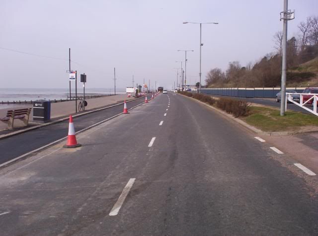
They have constructed a 2.5m wide cycle path where the parking used to be.
I have asked the Council about this and have been told
"The Western Esplanade works will be a Hybrid Cycle Lane. You can see example of these going in around the country. A Hybrid Cycle Lane is one where the footway, cycleway and carriageway are all separated and a different levels (see link for a picture of one
Cambridge Cycling Campaign » Newsletter 74 (October/November 2007) ).
It will be a two way cycle lane"
Now those linked photos are fine, but they all show a wide cycle path far away from the road carriageway. This new path is just 2.5m wide and there is no seperation from the traffic.
LTN2/08 clearly says things such as (my bold)
8.5.1 The minimum widths given in this section relate to what is physically required for the convenient passage of a small number of users. They do not take into account the need for increased width to accommodate larger user flows. Wherever it is possible, widths larger than the minimum should be used.
Practitioners should not regard minimum widths as design targets.8.2.2
A design speed of 20 mph is preferred for offroad routes intended predominantly for utility cycling**. This provides a margin of safety for most cyclists. The average speed of cyclists on a level surface is around 12 mph.
8.1.2 In general, offroad cycle routes in urban areas tend to be the least desired option, and it is usually better to cater for urban cyclists onroad if this is practicable.
8.5.2 ...
The minimum recommended width for a two way cycle track is 3 metres. If these widths cannot be realised, the facility may become difficult for some people to use....
8.5.3 In all cases where a cycle track or footway is bounded by a vertical feature such as a wall, railings or kerb, an additional allowance should be made, as the very edge of the path cannot be used
...Low upstand up to 150 mm - Add 200 mm
Vertical feature from 150 mm to 1.2 metres* - Add 250 mm...
At just 2.5m wide instead of 3.2m wide, do you think this is a bit narrow?
Now for the more serious thoughts...
- All design documents refer to cyclists as 1metre wide, requiring additional 0.5m "wobble space". This is why two way paths are recommended as 3m wide.
- As it's a two way cycle route eastbound cyclists will need to thread the needle between oncoming cyclists and 30mph oncoming motor traffic.
- Cycle tracks are to encourage novice cyclists, and family leisure cyclists. Would you be happy bringing your family down here where there's a risk that your children might meander into the path of oncoming traffic? I'm not.
- In France, British motorists have to fit adapters to prevent their headlights blinding oncoming traffic to their left. Motorists won't fit these adapters just to drive along the Southend Seafront, so therefore cyclists are going to be dazzled at night and therefore going to find it even harder to spot the gap between traffic and oncoming cyclists.
- The cycle track is around two inches higher than the carriageway. Therefore if a cyclist swerves onto the carriageway into oncoming traffic they CANNOT swerve back onto the cycle track as they'll get tripped over and fall off

For additional thoughts, the carriageway here floods in heavy rain. The drains look like this
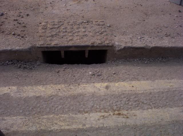
The camera broke when I dropped it, but these drains are still in use, but the bottom half is now obstructed by the tarmac surface of the cycle lane! In strong winds sand blows across the existing carriageway only to be swept away by car tyres. What will happen in the future? I expect the cycle track to get covered in sand* and also flooded whenever it rains; the carriageway will also flood in the rain and the cyclists will get drenched by passing motorists.
I really think that creating a two way cycle track at just 2.5m wide and not segregated from the traffic is a nightmare here. I am sh:tting myself.
So what's happening elsewhere?
Wowbagger posted a photo of Prittlewell Chase some time ago. They've finished painting the lanes now. I've been reassured that this is "a 0.5m door zone with a 1.5m cycle lane".
This might be what the asked for... but the parking bays are too narrow for a car to fit in
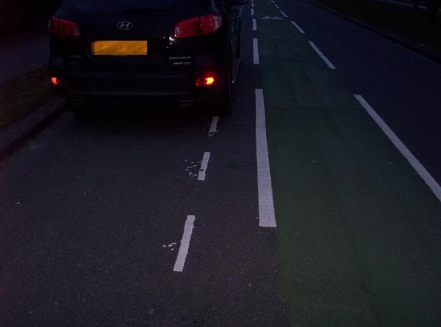
The door zone is actually 0.43m wide
The cycle lane is 1.3m wide reducing to
0.43m (yes forty three centimetres) in places
I give up. I really do.

* I used a sand covered seafront cycle track in France once. The sand caused other cyclists to lose traction and fall off.
** The seafront route is well used by cycle commuters.

