Ok, will do. What governs whether some saved in say bikehike - will be designated a Route or a Track?
bikehike gives you the option of saving something you've planned as a Track or as Route. The way it does Routes is pants IME.
In fact all it does, as far as I can see, is save a Track but repurpose it as a (dysfunctional) Route. It just gives Routes a bad name.
Right, I've got a bit more time now - Andy -
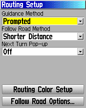
on the model of GPS you've got, basically in order to get 'navigational' bells and whistles (turn warnings, little bleep, backlight comes on,
unhelpful message displayed) - you have to be following a
Route.
(Before anyone else says it - yes it is
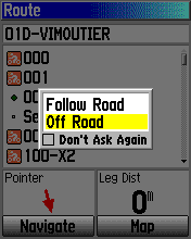
possible to navigate a Track, but frankly its more trouble than its worth, on these older Etrexes.)
A
Track, on the other hand, is a lowest-common-denominator format that can be seen as a 'just works' sort of thing, as long as you don't expect too much of it. That's why they are quite popular, espeially for sharing and distribution. By
colouring the Track and setting it to 'show on map' you are effectively getting a scrolling electronic version of a paper map that has been gone over with a highlighter pen. No prompts or anything - you just keep to the line on the map. Again - this is a
modus operandi that a lot of people understand and are comfortable with.
I can (have done) give someone a GPS preloaded with Tracks from one end of France to the other, with instructions to "switch it on in the morning, and off at night, follow the green line" - and that is all they need to navigate an approved route through France, having never seen a GPS before in their lives.
Most online planners work best as Track planners (BikeHike and BikeRouteToaster are actually optimised for Courses - which are a bit like Tracks on steroids, but anyway not usable on your Etrex) - you just let the 'follow road' stuff do its thing and then download the result as a Track, using the option to reduce it to 500 points. Quick and easy.
Or - but nobody does this do they? except me - turn the 'follow road' stuff off and then plot a 'join the dots' from turn to turn - this can then be downloaded as a Route (BikeHike only - BRT doesn't do Routes) and (provided there are fewer than 250 points) it should work on your GPS and generate prompts as each waypoint approaches. Less is more incidentally, when plotting this type of Route - don't use more points than you have to.
If the route has <= 50 points, you can opt to put your GPS into 'follow road' mode for a more satnav-like navigational experience.
250 points, at a very rough average of 1 per Km which is about right for laney UK conditions - will get you 250Km.
Likewise if autorouting, 1 point per 5Km is probably a safe average to use, in rural conditions - again 50x5 == 250Km.
A Track - 500 points is just about good for 100Km at a stretch. Although the Track you lay down while riding will be much denser - around 1 point per 60m. So will a Track generated by a Planner, be denser. So to stretch a Track like this to longer distances you have to downsample.

